NavList:
A Community Devoted to the Preservation and Practice of Celestial Navigation and Other Methods of Traditional Wayfinding
Re: Wobbly Prime Meridian
From: Gary LaPook
Date: 2010 Nov 23, 18:50 -0800
From: Gary LaPook
Date: 2010 Nov 23, 18:50 -0800
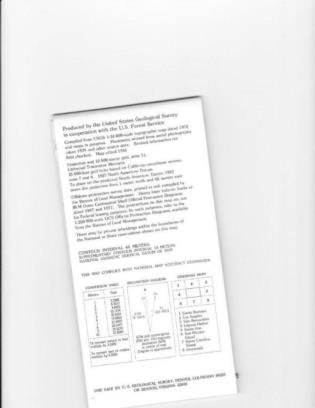
Here is an example of a legend that shows how to convert coordinates
on a map from NAD 27 to NAD83 (essentially WGS84.)
gl
On 11/23/2010 1:18 PM, Gary LaPook wrote:
gl
On 11/23/2010 1:18 PM, Gary LaPook wrote:
Hand held GPS units have much better accuracy than 100 meters. If you find that your GPS coordinates do not match up with coordinates read from a topographic map, it is probably that the map coordinates are based on a different datum than WGS84. For example, most topographic maps of the U.S. use NAD27 (North American Datum, 1927), check the legend on your chart for a notation of the datum being used. Some recently printed maps will also have a notation in the legend telling you how much and in which direction you must move coordinates to convert them to WGS84. The differences vary in different locations. Where I live in southern California, I must move the GPS WGS 84 coordinates 0.001' (6 feet, 1.85 meters) south and 0.055' (276 feet, 84.2 meters) east to convert the WGS84 coordinates to NAD27 to match up with my topographic map.
The original post gave the coordinates for the Greenwich observatory as N 51 28.674' W 000 00.088'. If you convert these to the Ordnance Survey Datum you get N 51 28.646 W 000 00.008'. so the longitude is only off by 30.3 feet, 9.2 meters.
If you check the "setup" screen on your hand held GPS you will probably find a place where you can choose the datum to use and I suggest that you do this if you need maximum accuracy and consistency with your maps.
WGS84 is a compromise datum that gives fairly good coordinates for the entire world but is not as good as the national datums, such as NAD27, for particular locations. WGS84 is accurate enough for flight operations and offshore but you should use the correct national datum for precise land navigation.
( And it is "datums" not "data.")
gl
On 11/23/2010 12:05 PM, Apache Runner wrote:Even more troubling is when it fails altogether. This happened to me once in the fog in a kayak in coastal waters. 100 m sounds about right for a hand-held device under decent conditions.


