NavList:
A Community Devoted to the Preservation and Practice of Celestial Navigation and Other Methods of Traditional Wayfinding
From: Louis Carrier
Date: 2023 Jan 30, 14:28 -0800
Hello Navlisters,
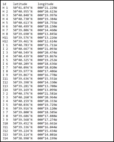
I found that this image of the Rampion wind farm, photographed from a place near Pagham (UK), is so interesting that I tried to add my humble contribution to this thread. I was fortunate enough to find online an interactive "marine chart". I then was able to extract the coordinates (latitude and longitude) for each wind generator I thought was on the image. I hoped that these coordinates could be as close as possible to the actual position of the generators. As previously said, the mast height from sea level to the hub is 80m. From this I constructed, for each wind generator, a vector in polar coordinates whose base sits on a spherical earth (raduis = 6370 km) and the other end is 80m above it. I converted these coordinates to their cartesian form to be able to manipulate the vectors with basic linear algebra (rotation and translation matrices).
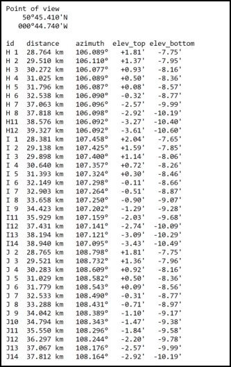
Frank Reed suggested to take the row of generators, wich are almost all in line, as a "near" LOP. It simplified a lot my search for the position of the photographer (the point of view). To make a long story short, here are the results I got from these informations. With two rotations and one translation I brought the "observer" from its position on he surface of the earth to a new one in the center of the "local coordinates sphere". Converting back those vectors to their polar form, I was able to plot each of them (azimuth and elevation) on a graph, I then had to move the image and scale the graph to achieve the best fit I could.
I agree with those who said that the rows we see in the picture are H, I and J.
According to the azimuth pointed in the picture, it would be nice to take a "future" picture with the moon rising behind the wind generators. The sun will be trickier to photograph.
The data files containing what I found are attached to this message.
Louis Carrier
46N 071W


