NavList:
A Community Devoted to the Preservation and Practice of Celestial Navigation and Other Methods of Traditional Wayfinding
From: Frank Reed
Date: 2022 Apr 24, 10:24 -0700
This latest transit of Phobos is by far the best (yes, WOW!). I wanted to try the "where are you?" side of this. Could we determine the position of the camera from the image? I didn't manage to find a time and date for this latest Phobos transit, but I went back to the very first photographed from the surface of Mars which was captured by the "Opportunity" rover eighteen years ago.
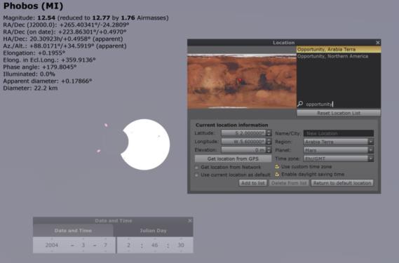
The time stamp in the caption is given as 02:46 UT (I'm sure the seconds of UT are known, simply not listed in the caption). See images below. I simulated the Opportunity transit in Stellarium trying various positions that would yield a grazing transit, as in the photo. Assuming that the time could be anywhre in that whole minute, between 02:46:00 UT and 02:47:00 UT, I found that the martian latitude could fall anywhere in the range from about 1.8°S to 2.1°S (since Mars is about half the size of Earth, that difference of 0.3° or 18' of latitude is roughly 9 nautical miles --Earth nautical miles). That's pretty good. Longitude is tougher without a time to the exact second and could be anywhere in the range from perhaps 3.3°W to 8.2°W. Assuming that the time is exactly 02:46:30, the best fit I found was at 1.95°S and 5.6°W.
Next I tried finding the location (final resting place) of Opportunity on Mars in Stellarium. Yes, it's listed, and the position given is 1.95°S and 354.5°E. At first glance I thought the longitude was a disaster. Then I noticed... "E". So converted to martian West longitude, that's 5.5°W. The position is a match in latitude and only differs by 0.1° in longitude. Near the equator that would be 3 nautical miles (again, Earth nautical miles). Pretty good!
If you're ever lost on Mars (how could you possibly be lost?!), and you happen to have a sky simulation app on your phone-like device, you could use Phobos to navigate on a lucky day. Capture a transit on video, take note of the appearance of the deepest moment of transit, and record the time to the nearest second. Assuming the ephemeris of Phobos is as good as the current ephemeris in Stellarium, you could determine your location to within a fraction of a mile.
In many ways this is like a position fix by lunar distances at known UT, which I also discuss in my online "Lunars" workshop (reminder "Celestial Navigation in the Age of Sail" is coming up, either April 30,May 1 OR May 2,3,4 and then that's followed one week later by "Lunars" either May 7,8 OR May 9,10,11).
Register:
- CN Sail with NavList discount
- Lunars with NavList discount
- CN Sail at repeat rate, if you have attended previously
- Lunars at repeat rate, if you have attended previously
Frank Reed
Clockwork Mapping / ReedNavigation.com
Conanicut Island USA


