NavList:
A Community Devoted to the Preservation and Practice of Celestial Navigation and Other Methods of Traditional Wayfinding
Was Earhart a Spy, Second spy theory
From: Gary LaPook
Date: 2010 May 24, 14:29 -0700
From: Gary LaPook
Date: 2010 May 24, 14:29 -0700
I wrote before:


"There have been many who have claimed that Earhart was on a spy mission
when she disappeared and have raised Earhart’s role in gathering
intelligence about Japan’s actions in the Mandated Islands. (I do wonder
however if any these theories were advanced prior to the 1943 Rosalind
Russell movie, Flight For Freedom, which had that story line.) I decided
to look at this from a piloting and aircraft performance point of view.
It turns out that there are actually two different theories. One, that
she was a spy herself, flying over the Japanese held Islands and taking
pictures of their installations with cameras hidden in her airplane. A
second theory is that she was not taking pictures herself but that she
would stage a disappearance to give the U.S. Navy the excuse to search
the Mandated Islands so that the Navy could take pictures of Japanese
installations. We need to look at these two different theories separately. "


--------------------------------------------------------------------------------------------------------------------------------------


Now lets look at the second theory, that she was to stage her own
disappearance to give the U.S. Navy a justification to search throughout
the Japanese Mandated Islands. Let's see if this would have worked by
looking at it from the flight navigation point of view.

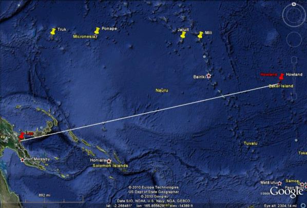
The distance from Lae to Howland is 2556 statute miles and the course is
078 degrees true (image 6.) ( I state all courses in relationship to
true north instead of magnetic north, true directions, not magnetic
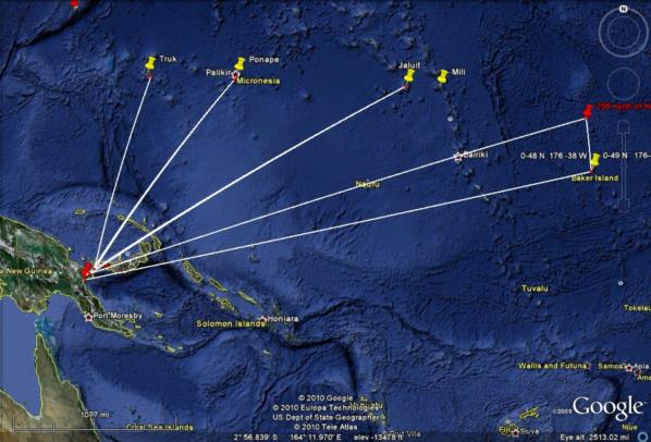
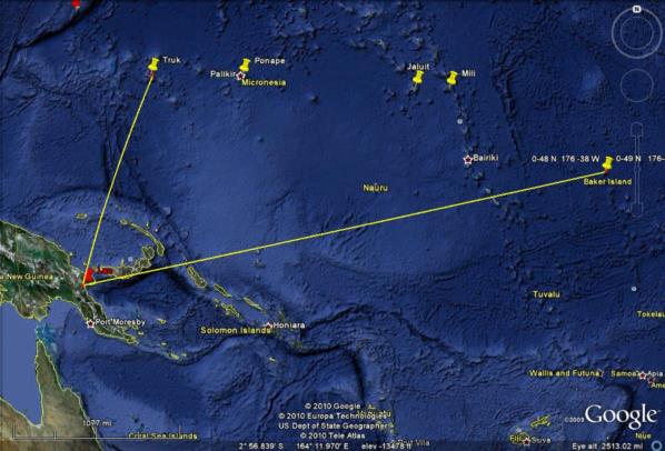
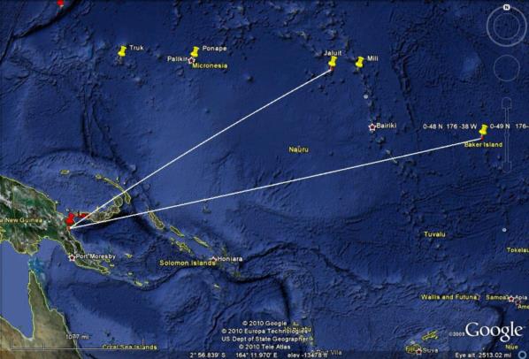
directions and distances are in statute miles.) Images 12, 13 & 14 show
the courses to Truk, Ponape and Jaluit. (I am not considering Palau
since it is so far off course.) The course to Truk is 18 degrees meaning
the plane would have to be 60 degrees off course to get to the vicinity
of that island. The course to Ponape is 38 degrees, off course by 40
degrees. To Jaluit is 60 degrees, 18 degrees off course.

Another way to look at this is to see how many miles off course they
would be if they were in the vicinity of those islands. Image 15 shows
the perpendicular distances from the course to Howland to the various
islands. Truk is 910 miles off course, Ponape is 770 and Jaluit is 580.

The commonly accepted level of uncertainty of in-flight dead reckoning
is 10% of the distance flown. So even without a navigator on board and
with Earhart doing her own dead reckoning navigation, just holding a
heading based on correcting for the forecast winds, and with no fixes in
flight, no celestial fixes and no visual fixes over an island, she
should not have been off course more than 255.6 SM either to the north
or to the south of Howland. Image 16 illustrates the area she might have
been expected to overfly on her way to Howland if using just dead
reckoning. It extends 255 miles north of Howland which is about 6
degrees off the course to Howland. (A like area would be south of course
but that is not important to this discussion.) Even though the area of
course uncertainty extends 6 degrees either side of course, you are more
likely to be closer to the course line than to the edges of the area.
The probability drops off gradually as you move further away from the
course line. With a navigator on board, obtaining celestial fixes fairly
regularly, the plane should be very close to the course line and it is
unlikely that it was ever near the edge of the area of course uncertainty.

Image 17 shows how far off course in excess of the area of course
uncertainty it would be to go to the islands. Since the course
uncertainty is 6 degrees these numbers are six degrees less than the
previous numbers, 54 degrees to Truk, 34 to Ponape and 12 to Jaluit.

The 10% area of uncertainty expands in the along course dimension too.
Even though the airplane (using dead reckoning) may have flown through
the course uncertainty area it is not going to be near the western end
of it since they flew through that area many hours prior to the last
transmission. The plane is not likely to be more than 255 miles short of
Howland nor likely to be more than 255 miles past Howland. Image 18
shows the final area of uncertainty (with the area south of the course
line omitted. It would be the same size as the area north of the course
line.) Like the uncertainty in the course, the plane is more likely to
be near the center than near any of the edges. Again, with a navigator
on board, the uncertainty would be much less.

Image 19 shows the line from Jaluit to the nearest corner of the final
area of uncertainty. This distance is 670 SM. It is slightly less to
Mili, 530 miles. It is 1460 to Ponape and 1880 to Truk.

The Japanese also understood navigation. It would be very difficult to
convince them of a legitimate need to search near Truk, 1880 miles from
the outer limits of her likely position or even to search near Mili,
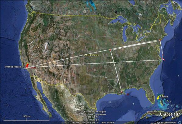
fully 530 miles away. To put this into perspective, image 20 shows an
analogous situation projected onto the U.S. If I were to disappear while
flying my plane from Los Angeles to New York my family would have a very
hard time convincing the police chief of New Orleans to make a search
for my plane in the swamps nearby. New Orleans is 780 miles off course,
about the same as Ponape.

Since the U.S. planners would have been aware that they would not be
able to pull the wool over the eyes of the Japanese, there is no reason
to believe that they would have attempted this deception.

gl

-search-area.jpg.thumb.jpg)

