NavList:
A Community Devoted to the Preservation and Practice of Celestial Navigation and Other Methods of Traditional Wayfinding
From: Joe Schultz
Date: 2010 Feb 2, 02:20 -0800
A few bones to chew on while you're all thinking:
1. At that point in the war the merchie losses weren't yet large enough for them to "get in line" with naval instructions. Time plus distance equals fuel. Profits matter. Monsarrat (sic) in his novel "The Cruel Sea" shows the naval point of view, albeit for the Atlantic. Economical speed is not achievable speed. My first tin can could do 36kts - economical speed was about 14kts.
2. A significant portion of a merchie captain's pay is a commission on the ship's profits. Good captains pay bonuses to their crews from this commission - builds loyalty. Everybody is financially motivated to make the runs profitable, and loyalty means you're not going to publicly bad-mouth the man that feeds you.
3. The sinking location is almost "too good" to the rhumb track. Perhaps done to save the good captain's reputation?
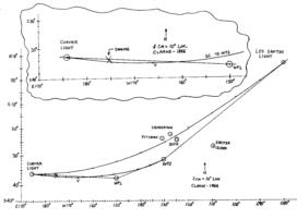
4. When I plotted the complete rhumb line tracks I thought "looks OK if you're going east of Ducie and not west of Pitcairn, but WP1 is too far south" - with experience you learn to visualize the great circle tracks before you plot them. Then I thought that perhaps Curvier Light --> WP1 rhumb was a joint track, meaning traffic for the canal shares the track with traffic for the horn, and reduces response time for naval forces. Perhaps they hadn't thought that far ahead at that point in the war. And I don't have any experience running from New Zealand to the horn, so I don't know how far south they'd dare run. There's an old saying about the southern ocean: no law below 40 and no God below 50. I believe Kermit has been down there (yes, a nickname. Hard earned, flying jets off a carrier. I'll use it until he tells me to stop.).
5. Location of WP2 makes sense if the "joint track" to WP1 is a valid thought, and if you wanted to keep traffic "out of sight" of Ducie, which the Pitcairn'rs used as a campsite when fishing.
6. Remember the Alamo! I mean remember the Pitcairn Archipelago! Curvier Light --> Los Santos Light great circle is not a safe route. I believe the normal peacetime routing was to the west of Pitcairn, by the way. French islands to the west of Pitcairn, so it makes sense to go east of Ducie.
Finding the great circle is easy in "the real world." Lay out the rhumb track, then compute (or use the conversion tables) the initial and final great circle courses. Plot as short straight lines. Then compute the vertex LAT and LON. Then use a big French curve or a flexible stick (two people) to "fair" the great circle. If you had time then you might compute two intermediate points - confirmation that you faired the track properly, and you get two points in one computation if you use the old method. It's a ten minute drill by logs, but no big deal with today's electronic number crunchers.
The attached plots took me about 20min (I did succumb to electronic means for the great circle points) - I'm getting slow! I used my Meridional Parts cheat sheet and a six-sided engineer's scale to quickly build the chart axes. Wasn't sure which ellipsoid to use.
My opinion, as to a possible compromise between profit and "get in line"? The good captain had no intention of going south of the vertex for the Curvier Light --> WP2 great circle. Rhumb (in the direction of WP1) until you cross the Curvier Light --> WP2 great circle. Then "cut the corner," going east until you hit the WP1 --> WP2 rhumb which gets you within 30mi of WP1 as you pass by. WP1 --> WP2 and WP2 --> Los Santos Light rhumb and great circle should be nearly equal distance, by the look of it. And all a moot point as he didn't make it that far.
All this assumes, of course, that the given coordinates are valid, meaning that they came from (then) classified sources. Unclassified numbers published in wartime are very suspect.
Joe
----------------------------------------------------------------
NavList message boards and member settings: www.fer3.com/NavList
Members may optionally receive posts by email.
To cancel email delivery, send a message to NoMail[at]fer3.com
----------------------------------------------------------------


