NavList:
A Community Devoted to the Preservation and Practice of Celestial Navigation and Other Methods of Traditional Wayfinding
Re: Translation of latin?
From: Peter Fogg
Date: 2010 Jun 4, 09:25 +1000
  The first attempt to "calculate" magnetic pole
From: Peter Fogg
Date: 2010 Jun 4, 09:25 +1000
  The first attempt to "calculate" magnetic pole
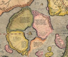
   In 1546 th, the famous cartographer Mercator made the first attempt to "compute" the location of the North Pole, causing the map lines corresponding to the compass readings at different points. He believed that these lines must intersect at one point - Pole. The attempt was unsuccessful, the line could not agree on one point, Poles have been found. But Mercator never left the idea and looking for other approaches to the problem. After more than two decades, in 1569-th year, he published the first map on which was shown to the pole, how! He depicted the polar region in the form of a huge continent, divided by four channels, in the center, at the North Pole, the great black mountain in the distance, outside of the polar continent, another mountain, smaller than a certain distance from it a small point. Another pole. The first hill is designated as the North Pole, the second - as «Polus magnetis respectu insularum capitis Viridis», but near the point of it is written «Polus magnetis respectu Corui insule». And let Mercator placed his Magnetic Pole between Siberia and California, but the idea to divide the geographic and magnetic poles is respected, and the introduction of an additional magnetic poles - a delight. After all, it was in the middle of the XVI century, when there was in the course of the theory of "magnetic hill."
Â
[From a Google translation of the original Russian, in:
On Fri, Jun 4, 2010 at 6:22 AM, Apache Runner <apacherunner@gmail.com> wrote:
Mercator had a map published posthumously of the Arctic regions. Â It had, among other things a huge magnetic mountain at the north pole, which presumably he assumed created the Earth's magnetic field.This map is called Septentrionalium terrarum descriptio.If I blow up and look at a region between that is a strait between California and Asia, there are two islands, which I take to be magnetic, and I'm assuming Mercator used to justify magnetic variance. Â ÂThe names next to the islands look like (if I have my old F=S convention correct)"Polus magnetis respectu insularu capitis Viridis"and"Polus magnetis respectu Corui insule"The context and what little Latin I know, and the size of the islands somehow leads me down the path of one being a "large" or "strong" island that has an effect on the magnetic field and the other (smaller) island being a "running"?? Â island.ÂSomehow he may be trying to capture the concept of secular variation and plain old variance by introducing two islands. Â Truly a bizarre, but understandable construction.Thanks!John H.Â


