NavList:
A Community Devoted to the Preservation and Practice of Celestial Navigation and Other Methods of Traditional Wayfinding


From: Paul Dolkas
Date: 2016 Jan 11, 21:54 -0800
3-D printing in plastic allows you to get much finer detail than metal. To print in metal you first make a “wax”, which you then use to cast the metal (at least, that’s how Shapeways does it). So you lose quite a bit of detail going thru two processes, rather than just using one.
Paul Dolkas
From: NavList@fer3.com [mailto:NavList@fer3.com] On Behalf Of Bob Goethe
Sent: Sunday, January 10, 2016 4:30 PM
To: paul@dolkas.net
Subject: [NavList] Re: Traditional navigation by slide rule (correction)
Good evening, Gary.
I'm staring at the photos you attached and trying to work my way through the logic in your text. But until you wrote, I hadn't thought about optimizing for time/speed/distance calculations. These kinds of calculations could be hugely useful.
I vaguely recall that there is some cosine-related equation that will let me note my speed at various courses relative to the wind, and figure out which yields the least time. (I sail slower on a dead run, but would be headed directly at a downwind objective; I sail faster when broad reaching, but am sailing further over the ground.) Figuring out my optimal course would be helpful. Right now in the real world, I just pick a course and hope for the best.
Anyway, there are some things that occur to me from your email.
1. We are going to want to develop a prioritized list of calculations we think would be useful. These help us determine which scales we need.
2. We need to make it easy for people to do the calculations...so we notate key equations on the back of the slide rule. This would be a good reason for making a single-sided rather than a duplex slide rule. If we 3-D print the box to store the rule in, we can also notate some equations on its surface and interior.
3. The user manual that comes with the rule is going to be a hugely important part of the whole. It is going to be a summary of key concepts in navigational mathematics. Set, drift, speed/time, great circle calculations, fuel consumption, distance to horizon, etc. We will be able to capture a lot of utility in a few equations that Bowditch deals with in dozens of pages of tables.
I have never yet taken my Bowditch to sea...but I have taken a slide rule. Now, if I can take a BETTER slide rule, or one that I better understand how to use, I will be ahead of the game.
4. I had not even thought of including helps for aircraft navigation. When you talk of allowing for speeds of "1 knot to 1,000 knots" it makes good sense...but jars my thinking, as I have never yet tried to solve a navigation problem while moving faster than 12 knots. But why not!
I am saving this email from you, and plan to come back to it to digest is once I get basic C/D/S/T/ST/A/B scales generated.
It is fun driving CorelDraw with VBA. You can start with a blank page, click to execute you code, and in less than a second you have a C-scale generated. I will eventually be able to generate an entire slide rule in 5 or 6 seconds...and changing from a 10" rule to a 6" rule will involve no more than tweaking a few lines of code.
And if I understand 3-D printing properly, we don't really have to select one-and-only-one material to use in the construction of the rule. We can print one rule in aluminum, and another in a particular plastic. It will be easy to experiment to see what materials are most suitable.
My dad thinks the thermal-expansion qualities of aluminum will make it unsuitable for a rule material. But I see that the US Air Corps produced an aluminum rule in WW2 and provided a number of cellulose inserts to manage different types of calculation.
Have a good week, Gary.
____________________
Bob Goethe
"As I sail, I praise God, and care not."
Luke Foxe, Arctic Explorer, 1634
This message was sent using recycled electrons.
From: NavList@fer3.com [mailto:NavList@fer3.com] On Behalf Of Gary LaPook
Sent: Sunday, January 10, 2016 1:55 PM
To: goethe{at}shaw.ca
Subject: [NavList] Re: Traditional navigation by slide rule (correction)
Correction
" The course is 100 degrees, the wind is coming from 250 so the relative wind angle is 150 degrees. (On a boat this would be a current setting 70 degrees so the relative current angle is 30 degrees):"
From: Gary LaPook <NoReply_LaPook@fer3.com>
To: garylapook---.net
Sent: Sunday, January 10, 2016 12:39 PM
Subject: [NavList] Re: Traditional navigation by slide rule
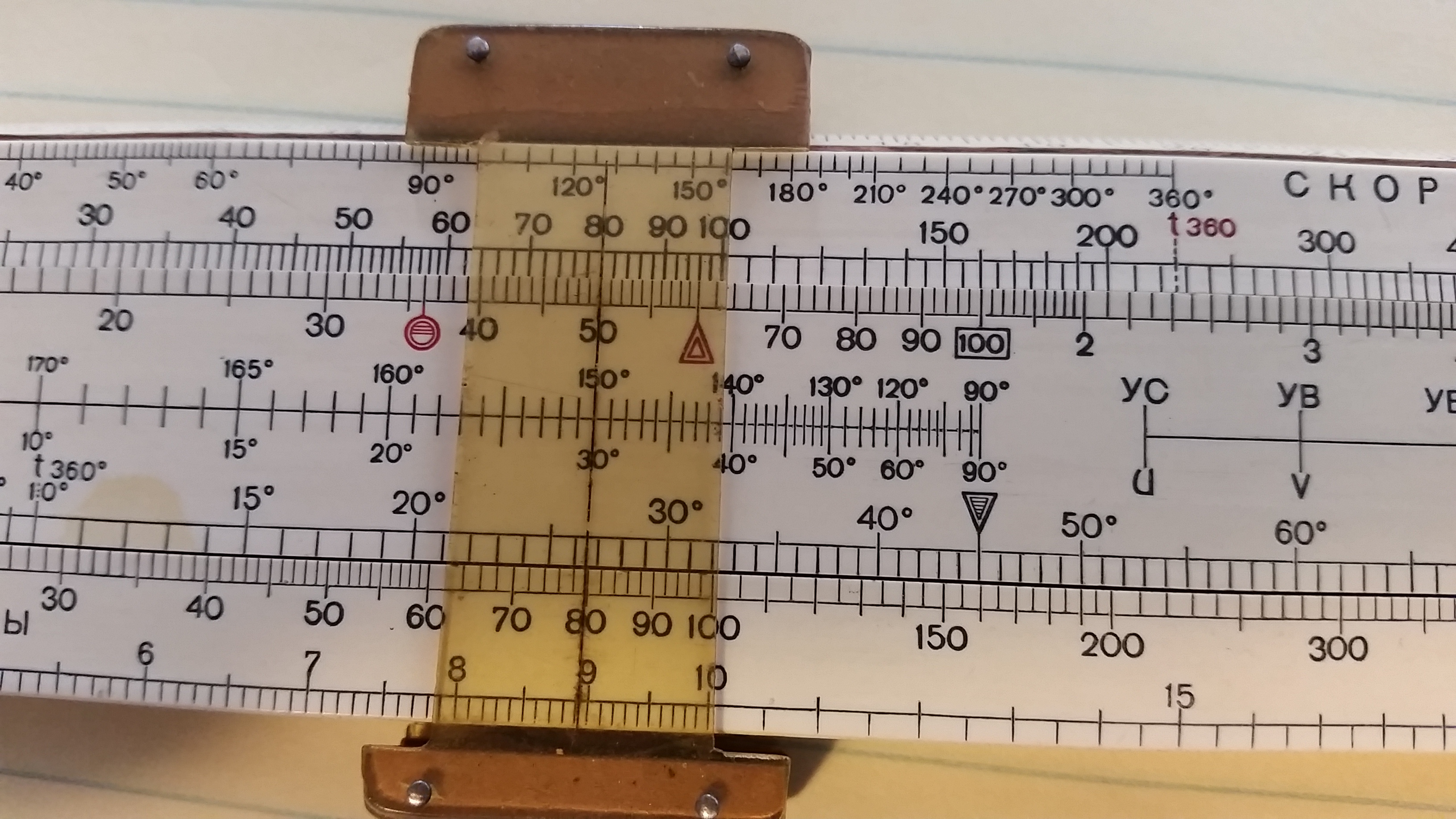
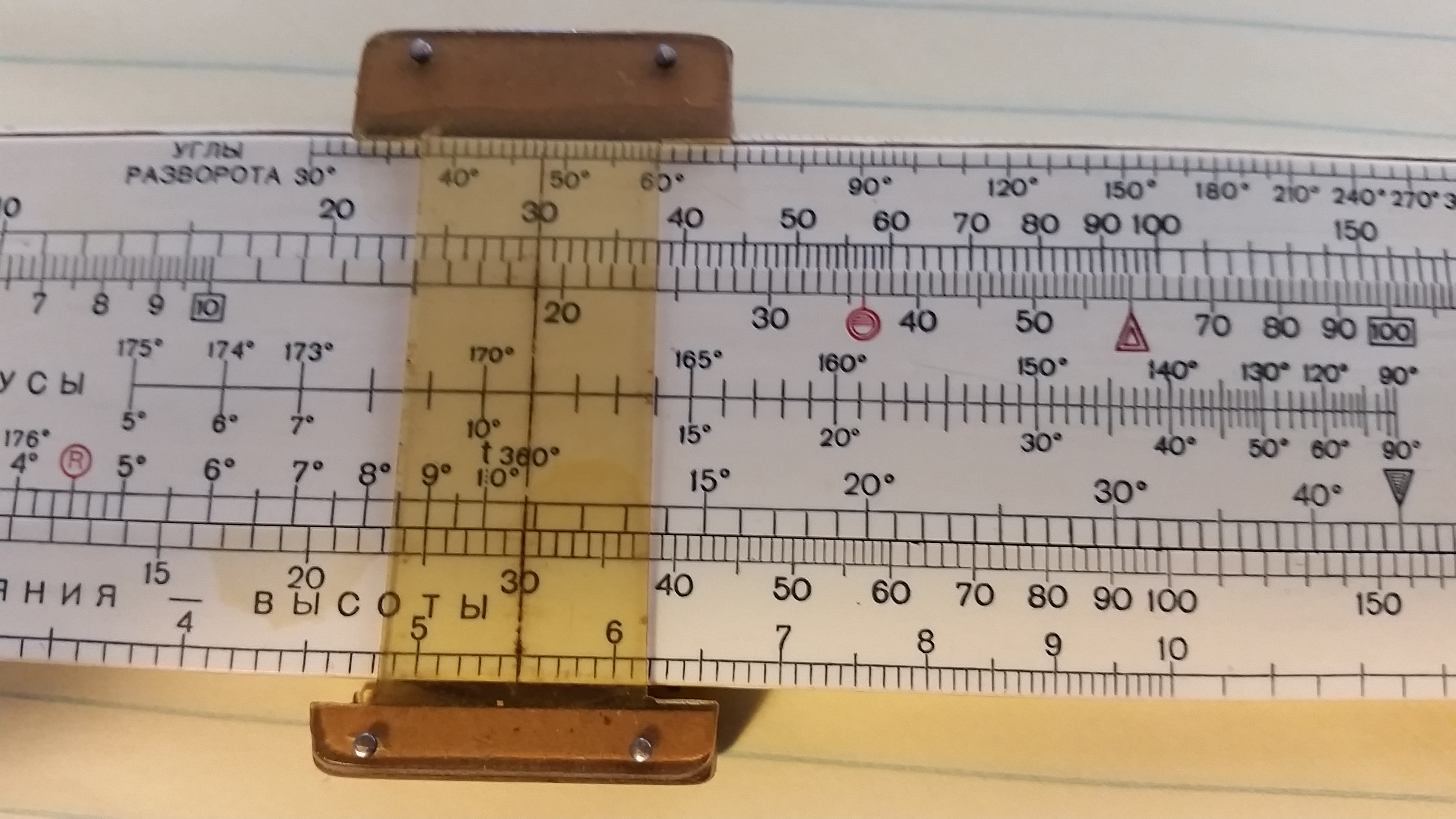
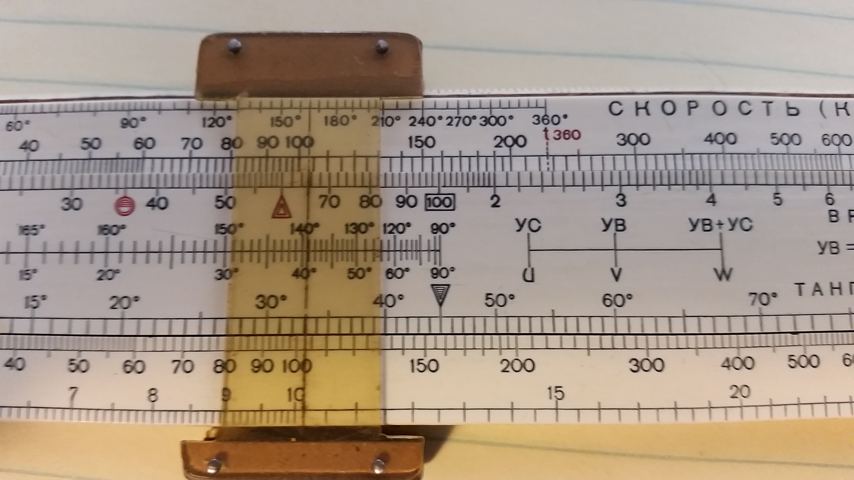
You may want to add scales for time-speed- distance computations. Here is a link to an image of a Soviet flight navigation sliderule:
The top scale is a "K" scale (three cycles) that allows for speeds from 1 knot to 1,000 knots. Like on an E-6B, the scale above 100 minutes is marked to indicate hours, the 120 is marked "2" etc. On the matching scale the 60 is marked with a pointer since this represents one hour, just like an E-6B. You could do something similar, using matching "A" and "B" scales covering a range of 1 to 100 knots or even use folded "C" and "D" scales to cover say 2 knots to 20 knots ( or, using standard folded scales, from 3.14159 knots to 31.4159 knots.)
The next scale down in the center of the slide is a sine scale that is used in conjunction with the "K" scale to do wind correction angle and groundspeed computions (set and drift for boaters) utilizing the law of sines. You line up your air speed with the relative angle of the wind (or currrent), move the cursor to the speed of the wind (current) and read out the wind correction angle on the sine scale. Then add or subtract this wind correction angle to the relative wind (current) angle, move the cursor to that angle and read out your groundspeed (speed over the bottom) on the "K" scale.
I am attaching three photos of mine to illustrate this. The course is 100 degrees, the wind is coming from 250 so the relative wind angle is 150 degrees. (On a boat this would be a current setting 70 degrees so the relative current angle is 30 degrees) Using 80 knots airspeed and wind speed of 30 knots. (For boats, 8 knot boat speed, relative current angle 30 degrees since current is shown as the direction in which the current is moving, winds are named for the direction they are coming from, and 3 knot current speed.)
The first image shows the cursor lined up on 80 on the "K" scale and 30/150 in the sine scale. Second shows the cursor moved to 30 on the "K" scale and reading out the wind correction angle of 11 degrees. The third image shows the cursor repositioned to 41/139 (11 added to 30 or subtracted from 150) on the sine scale and the groundspeed 104 K (speed over the bottom 10.4 K.) So, to maintain course, the heading of the plane or boat is changed to 111 degrees. We can see that we have a tailwind (following current) so our groundspeed is greater than the air speed. If the wind or current was on the nose then we move the cursor in the opposite diretion when combining the wind correction angle with the relative wind angle to find the groundspeed.
A scale like this might be useful on a navigation sliderule.
When I am training a student pilot in how to do this computation I like to grab his E-6B and say "here, use mine instead" and see that "deer-in-the-headlights" look on his face.
gl
Attached File:
(20160110_114506.jpg: Open and save)
Attached File:
(20160110_115803.jpg: Open and save)
Attached File:
(20160110_115824.jpg: Open and save)