Welcome to the NavList Message Boards.

NavList:

A Community Devoted to the Preservation and Practice of Celestial Navigation and Other Methods of Traditional Wayfinding

Compose Your Message

Message:αβγ
Message:abc
Add Images & Files
    Name or NavList Code:
    Email:
       
    Reply
    Three GPS data comparison: All different. Huh?
    From: Mark Coady
    Date: 2021 May 24, 10:55 -0700

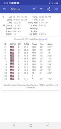
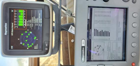
    The attached .pdf compares 3 GPS simultaneous satellite data outputs  (ok;  cell is 4 sec later to allow time to screen cap after taking pic of bridge outputs).  All were tracking similar Sat groups (pics). 

    1 is a Raytheon GPS on the bridge of M/V Syrena

    2 is the Raytheon Radar system GPS from the bridge of M/V Syrena.

    These two ship GPS have redundant antennas within a very few feet of each other.

    The last GPS output is from a Samsung Android smartphone also operated from the bridge a few feet away at the exact same time to add more data.

    The antenna/reciever location of the three are within a few feet, both altitude and surface locations,  but the sat tracker Azimuth/Elevation output differences surprised me.

    I expected that they would match closely and discrepancies would be small and very consistent.

     Clearly they are rounded to whole numbers, but that does not account for the uneven degree-plus gaps.

     I was expecting the larger azimuth discrepancy is explainable by mag vs true in the output settings of the two devices, based on an expected west variation at location, but it does not explain the other kinks and the varying range of values. (P/S changing from true to magnetic on the phone did nothing to the azimuth when the image regenerated?).

     I get satellites are not geostationary, but the updates are visible & constant so it doesn’t seem like update lag explains anything.

     What am I missing? In celestial we quibble on minutes and tenths...here I am swinging as much 2 degrees in some cases.

    I feel like I have my head in the oven and my feet in a bucket of ice water, but on the average I feel fine.

    Captain Confused

    M/V Syrena
    File:
    gps-compare.pdf
    File:


    File:


    Reply
    Browse Files

    Drop Files

    NavList

    What is NavList?

    Get a NavList ID Code

    Name:
    (please, no nicknames or handles)
    Email:
    Do you want to receive all group messages by email?
    Yes No

    A NavList ID Code guarantees your identity in NavList posts and allows faster posting of messages.

    Retrieve a NavList ID Code

    Enter the email address associated with your NavList messages. Your NavList code will be emailed to you immediately.
    Email:

    Email Settings

    NavList ID Code:

    Custom Index

    Subject:
    Author:
    Start date: (yyyymm dd)
    End date: (yyyymm dd)

    Visit this site
    Visit this site
    Visit this site
    Visit this site
    Visit this site
    Visit this site