NavList:
A Community Devoted to the Preservation and Practice of Celestial Navigation and Other Methods of Traditional Wayfinding
From: Antoine Couëtte
Date: 2010 Apr 1, 08:43 -0700
Hello to all,
Further to the better scale chart sent by Dave (thank you Dave), I have attempted to better pinpoint the OMAHANENO anchorage coordinates on GOOGLE EARTH from the indication of a 24 fathom anchorage spot just in the inlet and between both small islands of TAHOWNOE and OTOREA. On the chart, this position is slightly south of the extended direction of the "perpendicular coast" running east-west on a short distance on the north of the very small bay where the "watering place" is located.
Such exact spot also has the blessing of Mrs Joan Huxtable, as we can read from the last information kindly sent by George (thank you George), and it is also consistent with the revised position sent last night by Brad (THKS 2 !)
I therefore tried to make the best of it and I am announcing urbi et orbi that Sir Bayly's Vessel was anchored at exactly S 16°45'33" declination and E 208° 30' 12 " (W 151° 29' 48") Greenwich Longitude.
*******
From this position I reworked all LUNARS "backwards", starting from both the Position Itself and the published Lunar Distances only in order to derive the UT times of such LUNAR observations.
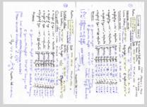
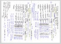
You will find the results detailed on the 2 page enclosure since I have no time to type and proof read them now. I did compute them twice and they should be free of error. "Numbercruncherollahs" will even be able to crosscheck the geocentric heights indicated. These should be accurate to better than 1" for the SUN and to better than 4" for the MOON (ref : E406 / VSOP87 / ELP2000 S2001 with UT and delta T values indicated). If not, please be so kind as to let me know.
IMPORTANT NOTE TO READERS : The full exercise here is to compute predicted heights (from a fully known accurate position and from reasonably known UT times - expected to be accurate to +/- 30 to 40 seconds of time) in order to compare them with the observed LUNAR heights. From that comparison, attempt establishing some conclusions on the published heights. Were they just corrected from Instrument error ? or corrected for dip ? and/or refraction ? and/or Parallax ? and for Augmented SD and/or for Parallax ?. Also check whether their accuracies would be "meaningfully usable" to position the ship in Lat/Long.
Let's comment the results now about such height differences :
07 SEP 1773
GOOD START !!!
The SUN is over the mountains of ULIETEA and this situation will happen for every observation. So, we will not be able to deduce anything reliable from the SUN heights in this whole example. EXCELLENT !
The MOON is just over the western tip of BORA-BORA in the distance, and moving to the West (yes ... also in the southern hemisphere apprently) so the MOON HEIGHTS should be more reliable.
Well ... the MOON height differences exceed 30' and the SUN height differences exceed 40' !!!!
This is totally unexpected ... unless - thanks to you Dave ! - on the morning of Sep 07th, as it was then, she was still underway from UHAHINE a nearby Island some 30 NM to the East !!! Which is a very good reason why we have such discrepancies on the height differences. Thanks Dave !
Therefore, no conclusion regarding the altitudes can be drawn from the observations of this day. :-((
08 SEP 1773
The Ship is anchored at OMAHANENO
NO SUN ALTITUDE REPORTED : the SUN azimut is 070°5 hanging over the pretty high terrain of ULIETEA, and
The MOON is over unrestricted waters, and its altitude differences range between 5' and 6' depending on the various assumptions made.
I am just curious to know the method they used to clear their dayly "LUNAR OF THE DAY" on that day ... Any idea Frank ? George ? Anybody ?
09 SEP 1773
Still at OMAHANENO anchorage
Restricted horizon for the SUN with (as expected) unreliable altitudes showing differences up to 25', and
MOON over (slightly?) restricted horizon with BORA-BORA in the distance with altitude differences not exceeding 6'
11 SEP 1973
Still at anchor at OHAMANENO
SUN over restricted horizon with height differences showing unexpectedly low value differences staying below 10' (how did they manage ?) , and
MOON over the sea horizon just in between the Eastern tip of BORA-BORA and the Western tip of TAHAHA and still running west. Maybe they just waited for the Moon to be just there.
Moon altitude Differences close to 15' though !!! What Happened ?
OVERALL CONCLUSION
IF the SUN heights are all observed from "distant horizons obscured by land" and therefore useless for our exercise, the MOON HEIGHTS were available and meaningful on the last three days. They remain the most interesting ones to analyse since the MOON PARALLAX is so important.
If we keep our assumptions than the published hights are corrected ONLY FOR INSTRUMENT ERROR, the Moon heights accuracy lies somewhere between 5' and 10' which is more than adequate for LUNAR Clearing Computations, but remains marginal - although not totally unpracticable - for conventional Celnav with the Marcq Saint Hilaire Method.
Unless there is strong eveidence to the contrary - and Wolfgang could youy PLEASE get us another page of Observations with at least observations at anchor from a point which we could identify on GOOGLE EARTH ... - I will for myself keep on computing all these LUNARs through keeping the very same assumptions hereabove with a Height of Eye equal to 23' to make it fully in line with George's suggestion.
Anybody is most welcome to check and question both my computations and my conclusions.
It really was an interesting excercise ...
and Captain Cook, must just be blessing us from Heavens !
Best Regards to all
Antoine M. "Kermit" Couëtte
----------------------------------------------------------------
NavList message boards and member settings: www.fer3.com/NavList
Members may optionally receive posts by email.
To cancel email delivery, send a message to NoMail[at]fer3.com
----------------------------------------------------------------


