NavList:
A Community Devoted to the Preservation and Practice of Celestial Navigation and Other Methods of Traditional Wayfinding
From: Frank Reed
Date: 2023 Mar 29, 11:14 -0700
David Iwancio, you wrote:
"The latest edition of Bowditch has tables for vertical angle distances (where the angle is measured between the top of the object and the horizon in front of it) for objects up to 46.5 miles away..."
Yeah, but that's just Bowditch, which has been a product of "design by committee" for some decades. I have never done it myself, but navigators who sail to the Azores, for example, regularly report seeing the highest peaks "peeking" at ranges of 100 nautical miles or more. In fairness to the Bowditch limits that you have described, that's a relatively unusual case. Then again, it's an important and useful case!
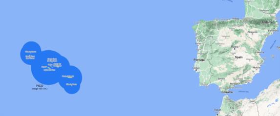
I took this as an opportunity to make a map that I have wanted for a long time: a chart of the visibility ranges of the various high points in the Azores. This map answers a simple question: how big is the target? If you're sailing in a relatively small boat either eastbound from North America or westbound from Europe, how difficult is to miss the Azores if your navigation is casual, or if you navigate by "primitive" historical methods? This assumes good weather, of course.
As you can see in the attached images, the Azores are big! I plotted each of the standard visibility ranges for the high peaks on each island. While navigators often report seeing "Pico" from great range, I have long suspected that they're making an assumption. If you're sailing from New England, for example, you'll see the peaks of the northwestern islands first, soon followed by Pico, the highest point in the Azores. Note that the ranges that I have used to plot this are for an observer with zero height above sea level. If you're on a larger vessel then each of the circles would be correspondingly larger (about 11.5 miles bigger in radius for 100 feet height of eye, for example).
Note that the visibility ranges can expand significantly when there is anomalous refraction such as when there is a temperature inversion or even when the atmosphere is just "leaning toward" an inversion.
Frank Reed
Clockwork Mapping / ReedNavigation.com
Conanicut Island USA


