Welcome to the NavList Message Boards.

NavList:

A Community Devoted to the Preservation and Practice of Celestial Navigation and Other Methods of Traditional Wayfinding

Compose Your Message

Message:αβγ
Message:abc
Add Images & Files
    Name or NavList Code:
    Email:
       
    Reply
    Re: Pilot charts
    From: Gary LaPook
    Date: 2008 Apr 15, 16:43 -0700

    glapook@pacbell.net wrote:
    
    
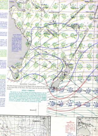
    I have attached a portion of the January Pilot Chart of the South
    Pacific Ocean published by the Defense Mapping Agency. Until I looked at
    this chart I had no idea that currents in the South Pacific could be so
    strong. The green arrows show the current  direction and speed in knots.
    For example, the current shown passing the southern end of New Zealand
    is 10 to 20 knots! And in the Gilberts it shows up to 30 knots! How do
    ships manage to maneuver against such strong currents?
    
    gl
    
    --~--~---------~--~----~------------~-------~--~----~
    Navigation List archive: www.fer3.com/arc
    To post, email NavList@fer3.com
    To , email NavList-@fer3.com
    -~----------~----~----~----~------~----~------~--~---


    File:


    Reply
    Browse Files

    Drop Files

    NavList

    What is NavList?

    Get a NavList ID Code

    Name:
    (please, no nicknames or handles)
    Email:
    Do you want to receive all group messages by email?
    Yes No

    A NavList ID Code guarantees your identity in NavList posts and allows faster posting of messages.

    Retrieve a NavList ID Code

    Enter the email address associated with your NavList messages. Your NavList code will be emailed to you immediately.
    Email:

    Email Settings

    NavList ID Code:

    Custom Index

    Subject:
    Author:
    Start date: (yyyymm dd)
    End date: (yyyymm dd)

    Visit this site
    Visit this site
    Visit this site
    Visit this site
    Visit this site
    Visit this site