NavList:
A Community Devoted to the Preservation and Practice of Celestial Navigation and Other Methods of Traditional Wayfinding
Mr. van Asten's method of measuring sunset with a bubble sextant
From: Gary LaPook
Date: 2013 May 6, 16:31 -0700
From: Gary LaPook
Date: 2013 May 6, 16:31 -0700
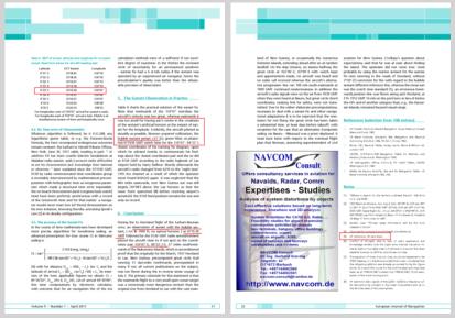
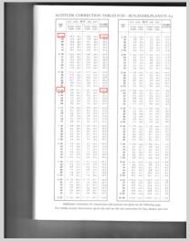
| I have posted about van Asten's 0719:30 Z sunset observation that he describes in his 2011 European Journal of Navigation paper. (I still can't understand how he got his paper published.) The theories in this paper then carried over to his theory about the sunrise observation on the approach to Howland.( It must have been a miracle that allowed the position based on this 0719:30 Z observation to be reported to Lae at least a minute earlier at 0718 Z.) See: http://fer3.com/arc/m2.aspx/Cugle-longitude-sunrise-sunset-LaPook-apr-2013-g23763 I pointed this out on the TIGHAR forum but there is another problem with this sunset observation that I didn't mention on TIGHAR because it was too technical for a general audience but the denizens of this forum, navigators all, might find it interesting. Mr. van Asten claims that a sunset observation taken at 0719:30 Z on July 2, 1937 provided a fix at 4̊ 33.5' S, 159̊ 07'E. If you do the computation you will find that at that time and at that location that the computed altitude (Hc) for the center of the sun was, indeed, zero degrees, zero minutes (0̊ 00.0') the classic "van Asten sunset" situation, (not the sunset method described in Cugle). So far so good. I have attached an excerpt from his published paper. In it he describes how this observation was taken, "... having suńs centre in the crosshairs of the sextant́s artificial horizon at the instant of sunset for the longitude. Evidently, the aircraft piloted as steadily as possible, Noonan acquired collimation, the bubble sextant preset +53́ [5], green filter, at plusminus 071930 GMT watch time for the 159̊07́- 04̊33́.5 closest coordinates of his running fix diagram..." His description shows that Noonan used his bubble sextant to take the observation. (This is important to his overall theory as he claims that the problem was caused by Noonan then using a marine sextant for the sunrise observation twelve hours later and that Noonan failed to account for the differences in the observations and thus made an error that led to the loss.) Mr. van Asten recognized that you couldn't take a "van Asten sunset" observation by simply setting the bubble sextant to zero because of the corrections that we all know about must be applied to the sextant altitude prior to comparing it to the computed altitude. Mr. van Asten states that Noonan set his bubble sextant to plus 53 minutes to account for these factors so that when the center of the sun was aligned with the "crosshairs" (of course there are no "crosshairs" in Noonan's Pioneer octant, you line up the center of the sun with the center of the bubble to take the observation. See: https://sites.google.com/site/fredienoonan/topics/pionneer-octant ) that the center of the sun would be horizontal, on the sensible horizon, parallel to the celestial horizon (dare I say, the "van Asten horizon"?) He shows how he got this 53 minute value that must be put on the sextant in note 5 of his paper: "[5] 37́ refraction, 16́ semi diam." So when the center of the sun is 53' above the horizontal established with the bubble of the sextant the sextant altitude (Hs) will be 0̊ 53'. To this we apply any index correction and, when using a marine sextant, a correction for dip (but not with a bubble sextant) to arrive at Ha (apparent altitude) before applying the rest of the sextant corrections. Assuming that there was no index error, then the Ha is also 0̊ 53'. Then Mr. van Asten subtracts 37' to account for refraction and subtracts 16 ' more for semi-diameter and so comes up with an Ho (observed altitude) of 0̊ 00'. Comparing the Ho of zero with the Hc of zero produces an intercept of zero NM thus confirming van Asten's coordinates for the 0719:30 fix. Any of you navigators see a problem with this? Test yourself, give it some thought before you scroll down. + + + + + + + + + + + + Wellllll, you don't apply a semi-diameter correction when you use a bubble sextant because you are measuring directly the center of the sun, not the limb as done with a marine sextant. So, redoing van Asten's computation, we eliminate the semi-diameter correction and apply only the refraction correction, Ha = 53' minus 37' makes the Ho = 0̊ 16' which then produces an intercept of 16 NM toward 293̊ T, the azimuth of the sun at that time and place. This means that his position is at least 16 NM in error! Anybody see another problem? It is more subtle than the first one, give it some thought and then scroll down. + + + + + + + + + + Mr. van Asten uses a refraction correction of 37' for zero degrees which he apparently got from some published refraction table although I have not been able to find it. Van Asten expects that Noonan had memorized this value in his past life because it is not found in the 1937 Nautical Almanac nor in Dreisonstok, the only books carried on the flight and that show up in the Luke Field inventory. The refraction tables in those books, as well as in the other common tables, Ageton, Weems and H.O. 214, only provide for altitudes of six degrees and higher, see:https://sites.google.com/site/fredienoonan/topics/refraction The 1938 Bowditch gives the refraction for zero degrees as 36' 20"; Nories, 1939 ed., gives it as 33.00'; Hughes, 1941 ed., also gives it as 33'; and the current NA states it as 34.5'. See the problem yet? Van Asten enters the refraction table at the wrong place, he takes out the refraction correction for an altitude of zero degrees, his hoped for Ho, when, in fact, you must enter the table with the Ha. Van Asten's Ha is 54', not zero, so the refraction correction is based on entering the table at 54', not at zero. Refraction changes very rapidly at very low altitudes so this makes a big difference. Looking at today's refraction table (attached) we see that the correct refraction correction that van Asten should have used for his computation is twenty-five minutes, twelve minutes less than the thirty-seven minutes that he used. Looking at the table in Bowditch, 1938 ed., the closest tabulated correction is for one degree, six minutes greater than van Asten's Ha, and that correction is 24' 45" showing approximately the same error of twelve minutes. So lets go through van Asten's computation again, this time doing it correctly. Hs = 53' IC - Dip - -------------- Ha = 54' Ref - 25' SD - --------------- Ho = 28' Hc= 0' ------------------ Int = 28 NM toward. Mr. van Asten should have plotted his LOP 28 NM toward 293̊ T, the azimuth of the sun at that time and place. This means that his claimed position is at least 28 NM in error!! This illustrates that Mr. van Asten does not understand even the basics of celestial navigation in spite of his claims. If he can't get this basic stuff right why would anybody believe that he did the other calculation (with his own computation method, not found in any book) correctly. His bio says that he got a degree in statistics and then taught high school, not the kind of expertise needed for analyzing Noonan's navigation. gl van Asten's 2011 EJN paper, excerpts: --------------------------------------------------------------- Table II. GMT of sunset, latitude and longitude for on board sunset. Read from below for aircraft heading east Latitude GCT Sunset Longitude 4̊31́.5 0718:45 159̊19́ 4̊32́.0 0718:56 159̊16́ 4̊32́.5 0719:07 159̊13́ 4̊33́.0 0719:18 159̊10́ 4̊33́.5 0719:30 159̊07́ 4̊34́.0 0719:41 159̊04́ 4̊34́.5 0716:07 159̊01́ 4̊35́0 0720:03 158̊58́ 4̊35́5 0720:14 158̊55 For longitudes west of 159̊07́ arrival for sunset is early.For longitudes east of 159̊07́ arrival is late. Match is at simultaneous means of time and longitudes rows. ... having suńs centre in the crosshairs of the sextant́s artificial horizon at the instant of sunset for the longitude. Evidently, the aircraft piloted as steadily as possible, Noonan acquired collimation, the bubble sextant preset +53́ [5], green filter, at plusminus 071930 GMT watch time for the 159̊07́- 04̊33́.5 closest coordinates of his running fix diagram, ..... 6. Conclusion During the to Howland flight of the Earhart-Noonan crew, an observation of sunset with the bubble sextant, [ A/c @ 7000 ft, no optical horizon ] at 0719:30 GMT followed by the 0720 GMT radio announcement placed the aircraft close to if not spot on the coordinates pair 159̊07́-E; 04̊33́.5-S, ... [5] 37́ refraction, 16́ semi diam. --------------------------------------------------- gl |


