NavList:
A Community Devoted to the Preservation and Practice of Celestial Navigation and Other Methods of Traditional Wayfinding
Modifications to 2102-D
From: Gary LaPook
Date: 2009 Apr 16, 19:11 -0700
From: Gary LaPook
Date: 2009 Apr 16, 19:11 -0700
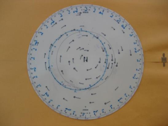
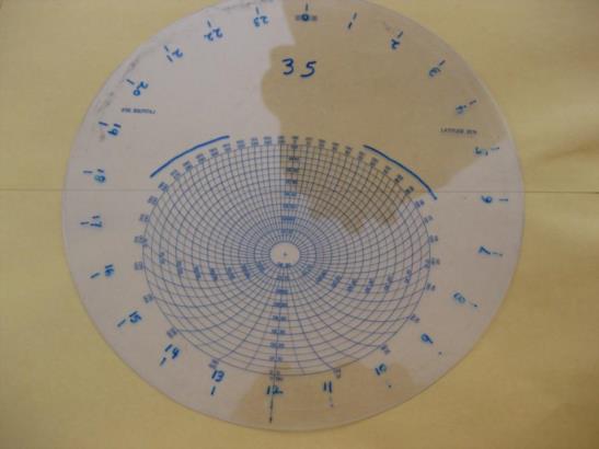
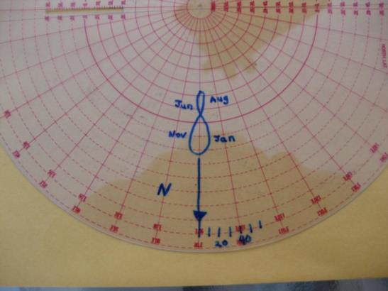
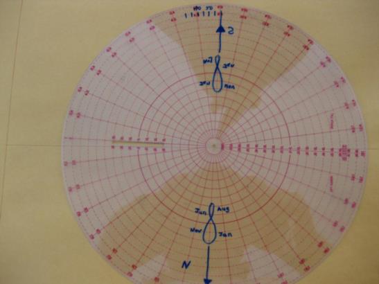
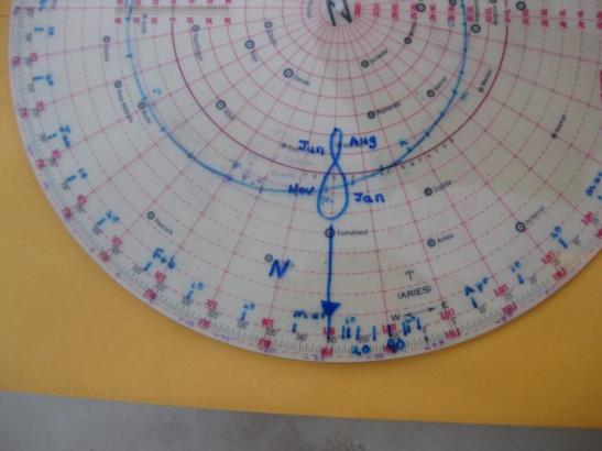
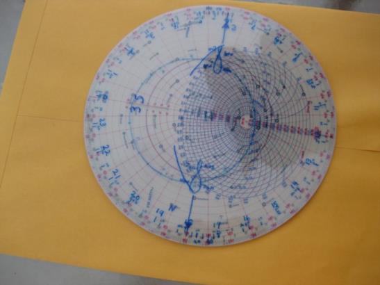
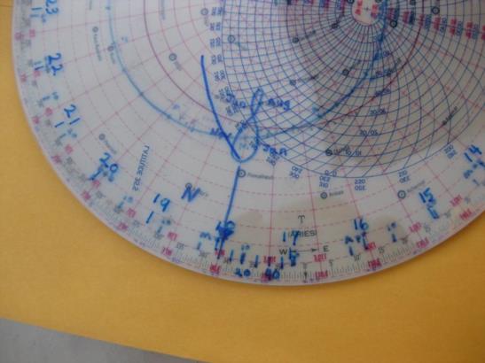
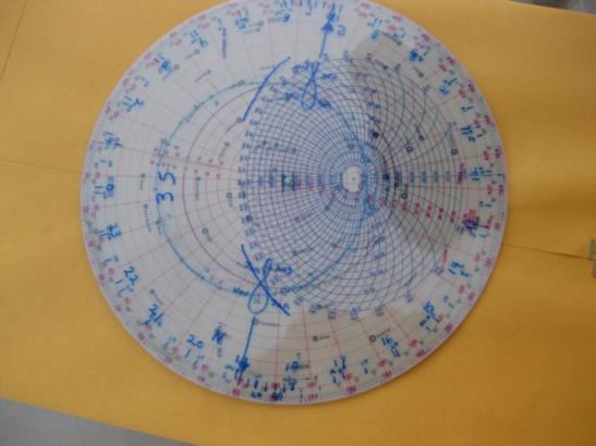
The recent thread about the 2102-E reminded me that I had modified my 2102-D many years ago to make it more useful and easier to use. These modifications are easy to do and take only a couple of hours. The 2102-D is basically a simplified planispheric astrolabe with some of the original astrolabe scales removed. I, basically, replaced some of these scales. I will describe these changes step by step. The first modification was to add a date scale to the star base. Image 148 shows the modified star base. Since Aires shifts approximately one degree per day compared to the sun, I only had to calculate the position of the sun and mark it on the base at approximate ten day intervals, the first, tenth and twentieth of each month and use the existing degree scale for the intervening days. To calculate this value take the GHA of Aries for the date and subtract the GHA of the Sun for the same date and time. I actually only did the calculations for the first and the fifteenth of each month and approximated the markings for the tenth and the twentieth. Next I modified the altitude-azimuth overlay (I'll call it the "blue scale" for simplicity) by placing an hour scale and mark at every 15 degree point with the "12" lined up with 180 degree azimuth. Image 151 shows this modification to the 35 degree latitude blue scale. At this point the modified 2102-D can be easily set to any date and time by mounting the blue scale on the base and lining up the hour of the LAT with the date and then advancing it one degree for each four minutes past the hour and the stars' altitudes and azimuths can then be determined from the blue curves. This is basically just like the star finders you buy at a planetarium or at a science shop. The next modification was to make an index for setting the date and time. I modified the red scale by placing marks every two and a half degrees to the right of the index and marked them every five degrees corresponding to twenty and forty minutes past the hour with the intermediate marks representing ten, thirty and fifty after the hour. See image 153. I created a similar scale for use in the southern hemisphere by flipping the red scale over and marking it similarly but in the opposite direction, increasing clockwise instead of counterclockwise. See image 154. Using this scale you mount it on the base and set the zero mark on the date and the markings then account for the minutes after the hour. Image 159 shows the red scale mounted on the base with the date arrow set on March 6th and the twenty minute mark lined up with 349 and the forty minute mark lined up with 354. You then place the blue scale on top and rotate it until the even hour of LAT is lined up with the minutes past the hour scale on the red scale and the 2102-D is again set to show the positions of the stars. At this point to use the modified 2102-D I still needed to know the time in order to set it so I decided to add some more scales to eliminate having to refer to the Almanac. To accomplish this I first added the ecliptic which was simple to do. I had the position of the sun for the first and the fifteenth of each month, the previously computed positions along the ecliptic, and the declination for the sun for the same dates. I plotted these points and then faired a curve through them by hand, see image 148. (Ignore the purple scale along the edge of the base, this is the Q correction for Polaris.) I then added analemnas for both the northern and southern indexes on the red scale, see images 153 and 154. I labeled them sufficiently so you could determine in which part of the year you should be on. I drafted the analemnas by using the red scale and plotting them on the star base based on declination and equation of time and then traced them onto the red scale. The intersection of the ecliptic and the analemna represents the position or the sun and the analemna corrects for the equation of time. With these modification completed it is easy to set the 2102-D for the time of sunset. Mount the red scale on the base and set it to the date. Place the blue scale on top and rotate it until the zero altitude curve (the outermost line) lies over the intersection of the ecliptic and the analemna and the 2102-D is now set up to show you the positions of the stars and you can read out the time of sunset (or sunrise) on the date/time scale. Image 160 shows the device set for March 6th. The zero degree blue curve is over the intersection of the ecliptic and the analemna so the device now shows the locations of the stars at sunset which we see occures at 1756 by reading the date/ time scale. The mark for 17 hours is to the right (counterclockwise) from the 50 minute mark and closer to the 60 minute mark. I decided to add one more scale, a blue curve representing a depression below the horizon of twelve degrees corresponding to nautical twilight. I calculated several points on this curve, plotted them on the blue scale and faired a line between these points. It is not necessary to draw this entire curve since you only need the portion covering the azimuth of the sun at rising and setting throughout the year. With this curve you can set it to nautical twilight using the same procedure as when setting it for sunset. Image 162 shows it set for twilight with the twilight curve superimposed over the intersection of the ecliptic and the analemna allowing you to read out the time of nautical twilight, 1855, and finding the positions of the stars at that time. gl --~--~---------~--~----~------------~-------~--~----~ Navigation List archive: www.fer3.com/arc To post, email NavList@fer3.com To , email NavList-@fer3.com -~----------~----~----~----~------~----~------~--~---
