Welcome to the NavList Message Boards.

NavList:

A Community Devoted to the Preservation and Practice of Celestial Navigation and Other Methods of Traditional Wayfinding

Compose Your Message

Message:αβγ
Message:abc
Add Images & Files
    Name or NavList Code:
    Email:
       
    Reply
    Re: Measuring (and Calculating) Dip - sighting technique
    From: Bruce J. Pennino
    Date: 2013 Mar 20, 22:52 -0400
    
    Hi Bill:
     
    I agree with Brad that the data looks first rate.  I have a method/procedure question when the horizon is varying by a meter or more.
     
    As you are looking through the scope at the varying level, do you take ten  evenly spaced , over time,  angles/elevations following the surface and average them? Or, do you keep ajusting the sighting hair up or down until you think you have an "average", and record that value? Then do other one, so on, until you are convinced that you have another  "average" value. Then average all of the so-called averages? Hope you follow that?      The issue of course is short choppy waves on top of long period waves. What sighting method  seems to work best?  I'll try your method first. 
     
    Of course if you are 50 or 100 ft in elevation, 3 ft  waves become somewhat less important.
     
    Thank you

    Bruce
     
    Holden, MA USA


    ----- Original Message -----
    Sent: Wednesday, March 20, 2013 2:10 AM
    Subject: [NavList] Re: Measuring (and Calculating) Dip


    Here are some data from last Tuesday at Henderson Bay in 34deg 44'S, 173 deg 07'E.
    Cloudless sky. Air Temp 25 C; sub surface temp 21 C. Wind speed zero. Wave height negligible though swell of about 1 metre visble off-shore (perhaps ex Typhoon Sandra).
    Height of eye in metres is given first, followed by dip face left and face right.
    1.89 2' 48" 2' 11"
    2.14 3' 05" 2' 35"
    3.10 3' 17" 3' 13"
    3.92 3' 27" 3' 36"
    14.5 8' 13' 7' 39"

    The last height of eye was taken from Google Earth. The others were measured with staff and level. AS I have noted previously, sometimes the horizon appears to rise and fall by up to 30 seconds and with high magnification the horizon is irregular and difficult to define.

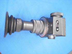
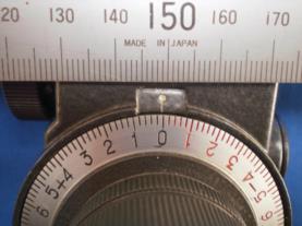
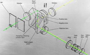
    For those who are not familiar with it, I have attached a diagram showing the light path of the Soviet N5 Dip Meter referred to in Brad's post and a couple of views of the instrument. It is a compact and light instrument. It is a little difficult to use because the movements required to view both horizons and bring them into coincidence are counter-intuitive, but once the tricks are mastered it gives the dip directly with a precision of 0.2 minutes on an easy-to-read scale.

    Bill Morris
    Pukenui
    New Zealand
    ----------------------------------------------------------------
    NavList message boards and member settings: www.fer3.com/NavList
    Members may optionally receive posts by email.
    To cancel email delivery, send a message to NoMail[at]fer3.com
    ----------------------------------------------------------------

    Attached File:


    Attached File:


    Attached File:


    : http://fer3.com/arc/m2.aspx?i=122992
       
    Reply
    Browse Files

    Drop Files

    NavList

    What is NavList?

    Get a NavList ID Code

    Name:
    (please, no nicknames or handles)
    Email:
    Do you want to receive all group messages by email?
    Yes No

    A NavList ID Code guarantees your identity in NavList posts and allows faster posting of messages.

    Retrieve a NavList ID Code

    Enter the email address associated with your NavList messages. Your NavList code will be emailed to you immediately.
    Email:

    Email Settings

    NavList ID Code:

    Custom Index

    Subject:
    Author:
    Start date: (yyyymm dd)
    End date: (yyyymm dd)

    Visit this site
    Visit this site
    Visit this site
    Visit this site
    Visit this site
    Visit this site