NavList:
A Community Devoted to the Preservation and Practice of Celestial Navigation and Other Methods of Traditional Wayfinding
Re: Horizontal Sextant Angles and False Horizons etc.
From: Peter Hakel
Date: 2013 Jun 6, 18:16 -0700
From: Peter Hakel
Date: 2013 Jun 6, 18:16 -0700
Sam,
You can also look here:
http://blog.navigation-spreadsheets.com/2012/07/07/horizontal-sextant-angles.aspx
for another idea from Greg.
Full disclosure:
The T-Plotter is my product (i.e., you'd be getting it from me) and you don't really need it for this; nevertheless, it is an option to consider.
Cheers,
Peter Hakel
From: Greg Rudzinski <gregrudzinski@yahoo.com>
To: pmh099@yahoo.com
Sent: Thursday, June 6, 2013 4:48 PM
Subject: [NavList] Re: Horizontal Sextant Angles and False Horizons etc.
----------------------------------------------------------------
NavList message boards and member settings: www.fer3.com/NavList
Members may optionally receive posts by email.
To cancel email delivery, send a message to NoMail[at]fer3.com
----------------------------------------------------------------
Attached File:

You can also look here:
http://blog.navigation-spreadsheets.com/2012/07/07/horizontal-sextant-angles.aspx
for another idea from Greg.
Full disclosure:
The T-Plotter is my product (i.e., you'd be getting it from me) and you don't really need it for this; nevertheless, it is an option to consider.
Cheers,
Peter Hakel
From: Greg Rudzinski <gregrudzinski@yahoo.com>
To: pmh099@yahoo.com
Sent: Thursday, June 6, 2013 4:48 PM
Subject: [NavList] Re: Horizontal Sextant Angles and False Horizons etc.
Sam,
The bottom of Grand Canyon isn't a good place for celestial navigation or for GPS. At least you have the Colorado river as a line of position to start with. The artificial horizon may not work as you have eluded to so a bubble octant will be the right tool for the job. Don't try using sextant or octant while transiting the rapids ;-)
Horizontal sextant angles can be done without a sextant. Take bearings using a hand held compass or binocular with a compass. The difference of the two bearings will be your horizontal angle to the nearest degree or two which should be good enough on the river with a topo map. Plot the bearings directly then do a horizontal angle as a check.
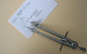
To plot the horizontal angle divide half the distance between mark A and B by the SIN of the horizontal angle. This is the radius of the circle of position. Plot using a compass
divider set to the radius distance. Arc the intersection off mark A and B then arc the circle of position. See attached example.
Greg Rudzinski
Horizontal Sextant Angles and False Horizons etc.
From: Sam Willis
Date: 2013 Jun 6, 08:44 -0700
Hello everyone. HELP!
From: Sam Willis
Date: 2013 Jun 6, 08:44 -0700
Hello everyone. HELP!
I am involved in a project that will involve the use of sextants in the Grand Canyon.
1. We will need to use a false horizon because we are in the middle of the desert. Am I right in thinking that a) using a false horizon makes it very difficult to shoot the stars? and that b) because of our lattitude (36) and the declination in August, I will not be able to do a Mer Pass on a 120 degree sextant because the sun will be too high to use a false horizon [and double the angle]?
2. It would be great to do some exercises with horizontal sextant angles. Can someone advise me on this because I am unfamiliar with it. Do I need a special plotting
tool?
many thanks
Sam Willis
-----------
Sam Willis
-----------
----------------------------------------------------------------
NavList message boards and member settings: www.fer3.com/NavList
Members may optionally receive posts by email.
To cancel email delivery, send a message to NoMail[at]fer3.com
----------------------------------------------------------------
Attached File:

: http://fer3.com/arc/m2.aspx?i=124269


