NavList:
A Community Devoted to the Preservation and Practice of Celestial Navigation and Other Methods of Traditional Wayfinding
Re: Great Circle Course via calculator & HO 208
From: Bruce J. Pennino
Date: 2016 Oct 17, 18:54 -0400
Bruce
Attached File:


Attached File:


Attached File:


From: Bruce J. Pennino
Date: 2016 Oct 17, 18:54 -0400
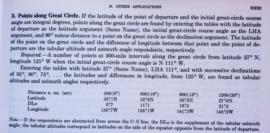
It has taken me far too long to finally understand the math for calculating
waypoints on a great circle course. I got it! It all “boils –down” to the
navigation triangle and the single equation- law of cosines. As described by
John Karl, CN in the GPS Age & John Letcher, Jr., Self Contained CN with
H.O. 208, the great circle distance law of cosines equation becomes
CosD = sinL1sinL2 + cosL1cosL2cos(LongDiff). D is distance in degrees.
Multiply by 60 to get great circle distance in NM. Knowing D and rearranging the
equation allows calculation of initial course. These equations easily solved
with hand calculator or use of tables. BUT what took me so long is that now the
navigator’s triangle has the additional information of one angle which never
changes for the initial great circle course and waypoints . Now using increments
of D,ie, 5 degrees or 300NM,10 degrees 600 NM, etc along the great circle, the
latitudes of the waypoints are calculated and then the long. difference can be
quickly calculated. Dutton’s method does the same thing but works backwards and
forward from the vertex (max. lat.) of the course . I finally understood
all this from Greg’s calcs. Thank you very much.
Dutton’s has one useful equation the latitude of the vertex: Cosine LatVer
= CosL1sin C where C is the intial course. The change in longitude from
the starting point to the vertex is sindt =cosC/sin LV.
Practically it seems to me way points only need to be calculated once
because this exact course is never precisely followed. As the trip progressed,
the navigator would update/change the course based on progress and by quickly
calculating a new D and Z with an updated fix. This would be done as
frequently as necessary based on the velocity of the vessel/plane. Tables like
H.O. 208 etc could be used for new D & Z . Progress could be compared to the
original route. I imagine GPS and auto pilots do this almost continuously.
Thanks for all helpful hints. Best regards.,
Bruce
From: Greg Rudzinski
Sent: Saturday, October 01, 2016 10:33 PM
Subject: [NavList] Re: Great Circle Course via calculator & HO
208
Bruce,
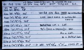
See this Pub 229 great circle solution for waypoints 300 nautical miles apart for your example. Enter the Pub 229 page for LHA 49 ( initial GC course) and Latitude 35°. 90°- distance in degrees to way point is used for the declination entry. Hc = way point Latitude and Z = difference in longitude from departure to Way point. Hopefully this will help with your Pub 208 solution.
Greg Rudzinski
Attached File:

Attached File:

Attached File:


