NavList:
A Community Devoted to the Preservation and Practice of Celestial Navigation and Other Methods of Traditional Wayfinding
From: Frank Reed
Date: 2020 Jan 28, 11:06 -0800
Igor S, you wrote:
"This possible application would lead perhaps to a return of radio sextant as a standard ship navigational equipment ... does it make sense?"
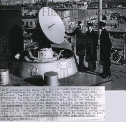
Only if the "radio sextant" is real technology with reliable accuracy, and only if it's relatively inexpensive. If it was real technology in early 1959 when various media published short "gee whiz" articles about it, then why did it disappear from naval vessels? If it worked, it would have been directly valuable for real practical navigation back then. Where did it go? There are a couple of possibilities here that come to mind. Most likely, it didn't work well, it was an experiment that failed, and the few press releases about the tech were overly optimistic. It's also possible that the hardware identified as radio sextants were smoke-screens, some other classified military hardware masquerading as radio sextants.
Also note that this technology is not magic. It suffers from the same problem that any automated sextant must overcome. How do you determine the local vertical or horizontal? If you're on a ship pitching up and down on ocean swells, any automated sextant whether operating in the visual spectrum or in radio will need some system to cancel out motion. The angular position of the Sun must be resolved against the local vertical. Otherwise it is useless. Apparently the experimental system in 1959 was tied in to an inertial navigation system which provided the vertical. We know that astro-inertial systems were essential to ICBM targeting in this period, and perhaps the radio sextant experiments were an attempt to build a better missile targeting system. I don't see any historical evidence that it was ever used for marine navigation except in experiments.
Also consider the problem of the "image" of the Sun or Moon. How could an automated radio system in 1959 determine the exact center of the Sun or Moon in the radio spectrum to the nearest minute of arc or better? Unlike in visible light, the radio image of the Sun has no sharp limb, and the brightness across the image can vary significantly. The Moon in radio has phases just as in visible light. Averaging over the disk would yield a position for the Sun (or the Moon, with a simple phase model) accurate to maybe 5-10', but I wouldn't expect much better than that. A modern system could benefit from a "reference image" of the Sun or Moon provided (perhaps once an hour) by ground stations. Or an automated modern system might be able to do better than averaging using a little "AI" to detect and ignore hotspots in the Sun's radio image. But there are real instrinsic problems with getting an accurate fix from radio spectrum images.
For a modern application of this radio sextant, start with two basic questions: what is the minimum radio "telescope" that can image the Sun at one minute of arc resolution, and what is the minimum inertial system that could be used to determine the local vertical reliably to one minute of arc or better? What would those two minimal systems cost?
Frank Reed


