NavList:
A Community Devoted to the Preservation and Practice of Celestial Navigation and Other Methods of Traditional Wayfinding
From: Yves Robin-Jouan
Date: 2013 Apr 9, 02:07 -0700
Jeremy C said: "These solutions seem squarely aimed at military applications. The hardware cost, both initial and upkeep, would be very high."
Yes, some components originates from GOTS list (Governmental OTS), but can be really industrialized at low cost.
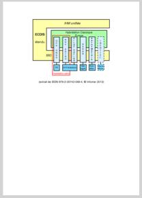
As suggested by Jeremy, for merchant Marine applications, ECDIS is used as an integrating platform for a number of sensors: GPS-GNSS, optronic turret, RADAR, sounders and IMU. E-LORAN should be integrated as an extension. The same optronic turret will be used when passing from coastal navigation (with terrestrial bearings) to high sea navigation (with celestial sights).
See a simplified block-diagram in the attached file (sorry for the French: etendu=extended, unifiee=unified, tete=head, cotier=coastal).
Regards.
Yves RJ
----------------------------------------------------------------
NavList message boards and member settings: www.fer3.com/NavList
Members may optionally receive posts by email.
To cancel email delivery, send a message to NoMail[at]fer3.com
----------------------------------------------------------------


