NavList:
A Community Devoted to the Preservation and Practice of Celestial Navigation and Other Methods of Traditional Wayfinding
Re: Digital Image CN Exercise
From: Marcel Tschudin
Date: 2010 Apr 6, 15:09 +0300
From: Marcel Tschudin
Date: 2010 Apr 6, 15:09 +0300
OK, Greg. I therefore proceeded with your Pixel scale of 0.097 Minutes
of arc per Pixel corresponding to 0.001616667 degrees of arc per
Pixel. The location obtained with the scale derived from the green
disc will only be mentioned for reference.

In the mean time the dip-error has been located and corrected. The
formula was actually correct but only used to verify whether the
object is above or below the visible horizon. I didn't remember that
the results shown in apparent coordinates are provided relative to the
astronomical horizon and not to the apparent one. The too high value
which appeared in the output referred to the selected "standard
location" which was different to those used for solving this problem.

The rest seems now to be straight forward. The locations are shown in
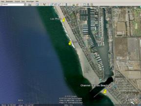
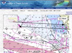
the attached screen shot of Google Earth and the location where the
photo was taken in the NOAA chart.

The horizon is claimed to be at 2468 Pixels below the UL (the image is
actually cut at 2464 Px); the UL is therefore 3.989933333 degrees
above the apparent horizon.

At the given date and time:
3 April 2010, 01:57:41 UTC
the local meteorological conditions are found in the History data for Oxnard, CA

http://english.wunderground.com/history/airport/KOXR/2010/4/2/DailyHistory.html?req_city=NA&req_state=NA&req_statename=NA&MR=1
Temp: 13.9°C and Press: 1017.2 hPa
using these data, the apparent heights above the horizon are as follows:

At Loc 0, the location initially provided (aLat=34°10'N,
aLon=119°14'W, Height of eye 13 ft.= 4 m), the sun's position would
have been:
UL = 3.997120833 degrees above the horizon (instead of 3.989933333).
The photo must have been taken slightly south of this location where
the sun sets slightly earlier.

At Loc 1 (34.274415 N, 119.288867 W) which has been found by trial and
error the UL of the sun corresponds with sufficient accuracy to the
one where the photo could have been taken:
UL = 3.9896 degrees above the horizon (instead of 3.9899).

Regarding the different locations mentioned here see attached file
"_All LOCs.gif" and "_Chart.gif".

Finding the off-shore oil rig:
Measuring the distances in x-direction between centre of the sun to
the oil rig in the original photo:
Sun: Right limb = 744 Px, Left limb = 418 Px, the Centre is at 581 Px
Oil rig (about):
Right edge = 146 Px, Left edge = 52 Px, the Centre is at 99 Px
Angular distance between sun centre and oil rig centre: 482 Px =
0.779233333 degrees.
Photo:
Note: The azimuths are counted from South = 0 degrees to West = 90 degrees etc.
The azimuth of the sun's centre is 93.90984 degrees (thus slightly
north of west direction)
The oil rig is about 0.779233333 degrees South of the sun's centre.
The azimuth to the oil rig is therefore 93.13060667 degrees
A line with this azimuth drawn from Loc 1 passes in about 14.2 km
distance about 1.4 km south of the oil rig Gilda.
By drawing a parallel line which crosses this oil rig one obtains at
the coast the location "Loc Photo" which lies in the opposite
direction of the initial Loc 0.

So, something is still going wrong and I realise also what. My program
calculates the apparent position of the centre of the sun. The
refraction is calculated for this position to which I added half of
the observed height of the flattened sun. This is likely to be
slightly different from calculating the apparent position for the top
of the sun. In an other part of my program I actually have provided
the possibility to select a location relative to the body's shape from
-1 (lower limb) to +1 (upper limb), but unfortunately not in this part
where it would first have to be added.

Regarding your "extra credit". The first could be done manually
knowing the distance which is behind the apparent horizon. The second
I have to pass since I'm not a bird watcher, I hardly can
differentiate between a gull and a sparrow ;-)

Marcel

P.S: By using the different scale of 0.100 Minutes of arc per Pixel
Loc 1 would be about 15 km further north, about 2.5 km after Ventura.


