NavList:
A Community Devoted to the Preservation and Practice of Celestial Navigation and Other Methods of Traditional Wayfinding
Re: Digital Image CN Exercise #3
From: Marcel Tschudin
Date: 2010 Apr 11, 13:07 +0300
From: Marcel Tschudin
Date: 2010 Apr 11, 13:07 +0300
Greg,

Thank you for this exercise. I had in mind to ask you for one with the
sun at a high altitude in order to see what can be achieved with more
predictable refraction.

Proceeding with your data, I get the following coordinates for the photographer:
Using LL:
34.194933 N, -119.246715 (W)
Using UL:
34.195451 N, -119.246592 (W)
I proceeded then with the mean of the two locations, with an
Azimuth Sun = 36.77653 (counted from South)
However, looking at the NOAA chart doesn't show a light house in this
area. (Or, did I miss it?) I proceeded then with the island. The cliff
and the lowest edge of Anacapa Island is 0.9059375 deg further in West
direction, having an azimuth of 37.6824675 deg (from South).
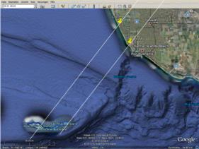
A line in this direction crosses the West Anacapa Island. This would
mean that the Middle and East Islands would be hidden behind the
horizon; this however would mean that the height of the hidden islands
wouldn't exceed about 30m (about 100ft). Looking at them with Google
Earth gives me the impression that they are likely to be higher. As a
check I drew a parallel line from the eastern etch of the Anapaca
Islands and this passes close to your assumed location. So, what went
wrong? In the mean time I did indeed do some modifications to the
program but the checks I performed indicated that it seemed to work
again correct. If the information of my program is correct you changed
in CA to summer time on 4 April. Could it be that you missed this when
converting local time to UTC?

I attach a screen shot showing your assumed location as "Pt LL 0", the
mean location as "Loc mean" and the mentioned azimuth lines to the
Anacapa Islands.

Marcel


