NavList:
A Community Devoted to the Preservation and Practice of Celestial Navigation and Other Methods of Traditional Wayfinding
From: Modris Fersters
Date: 2022 Oct 23, 12:37 -0700
The famous Cook’s first voyage took place from 1768 to 1771. James Cook had no chronometer on board of HM bark “Endeavour”. He calculated the longitude using Lunar distance method. The first Nautical Almanac containing all the necessary data to do the calculations was publiched in 1767 and was printed annualy for some years in advance . It seems obvious when James Cook left Plymouth he had Almanacs for years 1768-1771. But in fact he didn’t ! He had on board only two Almanacs (for years 1768 and 1769).
But Cook’s journals show that Lunar distance method was used also during years 1770 and 1771. Question is: how could he calculate longitude without Almanac data (without precomputed lunar distances that typically were printed in 3 hours intervals)???
Some authors speculate that maybe the astronomer Charles Green had handwritten exemplars of these almanacs. Others say that Green was a proffesional astronomer who could somehow calculate these data. But in this case it is not clear how these calculations could be done after the death of Mr. Green (logbook reveals that Lunars were taken also after Green’s death).
Maybe some experts of the history of navigation can explain this situation. I will be very glad to get more information.
I will present my version.
In 1763 Nevil Maskelyne published his “British Mariner’s Guide” (I found pdf version of this book in NavList archive) where he describes how to calculated the longitude from Lunar distances. There were no Almanacs at that time! All the data necessary for clearing Lunars were computed for the each individual set of observations. Maskelyne published Mayer’s tables for years 1760-1780 in this eddition.
I tested these tables to find the complexity of the calculations. The method described in the book was based on a different principle than usual comparing cleared Lunar distance with precomputed Geocentric distance. He compares Ecliptic longitudes of the Moon and the reference body (in fact it is the same, but in different coordinat systems).
When I read this book for the first time and started to study the calculation of the Moon’s ecliptic longitude, my first reaction was: Oh My God, it is imposible to understand these nightmares! But then I said to myself: just calm down! Let’s try to work out some example! And I was surprised that these calculations didn’t seem to me complex anymore. Yes, they were long (and required attention), but not complex. Only addition and substraction were needed and some interpolations which could be done by help of logarithmic slide rule (or historicaly-by Gunters scales; Maybe someone knows if logarihmic slide rules could be on board of “Endeavour”?).
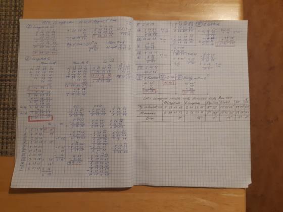
I will add pages of my paper work to ilustrate all the math to calculate the ecliptic longitude of the Sun and Moon, the Equation of time, Moon’s ecliptic latitude, Moon’s paralax, Moon’s SD and Moon’s hourly motion. It took for me about 1,5 hours. I added a table where I compared my results with those from Nautical Almanac 1769.
These calculation are based on Mayer’s tables. They are not something mystic or magic (as I used to think), this is not a rocket science. Tables are simple and convenient.
The Mayer’s tables for calculating Moon’s and Sun coordinats are quite compact, but in this 1763 eddition are not very accurate (in 1763 it was considered that if you could get the longitude to 1 degree it was a good result, because dead reckoning could be wrong 5 or even 10 degrees). The more accurate version of Mayer’s tables was published by Mascelyne in 1770. This latest version of Mayer’s tables was used to compute also the first almanac data for 1767.
My speculation is:
James Cook had 1763 “British Mariner’s Guide” on board of “Endeavour”. Maybe he had the last version of Mayers tables, becauce Charles Green was an assistant of N. Maskelyne. Therefore Cook was able to calculate his longitude even without Almanac.
Maybe someone has more information about this issue?


