NavList:
A Community Devoted to the Preservation and Practice of Celestial Navigation and Other Methods of Traditional Wayfinding
From: Frank Reed
Date: 2013 Dec 26, 14:19 -0800
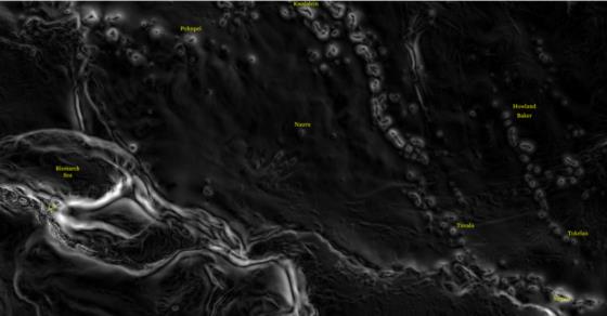
I've made some images showing the deflection of the vertical (the difference between a celestial fix and a GPS fix) from the NIMA "EGM2008" gravity map for the eastern USA/western Atlantic and for the equatorial Pacific from New Guinea to the vicinity of Howland Island. These are greyscale images on a simple one-to-one projection. There are 24 pixels per degree of latitude and longitude. For those of you with enough graphics-savvy to read pixels, the grey values are equal to the deflection of the vertical in seconds of arc multiplied by 4. So if a pixel's RGB value is 36,36,36, that implies that the deflection there is 9 seconds of arc. In simple terms, brighter shading indicates greater deflection. The direction of deflection is not indicated in these plots, but you can often guess. Approaching an island, the deflection is almost always in a direction away from the island.
In the eastern USA/western Atlantic plot, it's interesting to see how difficult it is to spot familiar features of North America. The Appalachians are faintly visible. The Adirondacks show up nicely as a dome (labeled), but no features of New England, for example, are otherwise apparent. Since I previously proposed sailing from Newport, RI to Bermuda, I've marked Newport. You can see that the deflection of the vertical near here is very small: just three or four seconds of arc.
Across the whole western Atlantic, Bermuda is clearly the largest gravitational anomaly in terms of local tilt. Approaching Bermuda the vertical tilts away from the peak of the hill by as much as 45 seconds of arc. A celestial fix taken ten or twenty miles from Bermuda, especially to the west or north, would place a vessel three-quarters of a nautical mile further out to sea than a GPS position.
Notice also the very nice delineation of the Bahama Banks and the Tongue of the Ocean. The mid-Atlantic Ridge is also clearly visible in some detail, and if you're thinking, "hey we could use this difference between celestial fixes and GPS to map the seafloor!", yes, we could. And in fact this gravitational data, primarily derived from satellite orbits, is the primary data source for the bathymetry in many parts of the world's oceans. It's not often noted that maps created this way are only approximations to the actual ocean floor.
Out in the western Pacific, we're seeing some major tectonic features so there are some areas with much greater deflection of the vertical. As I noted previously, the gravitational hill at Howland Island is relatively modest. The intensity scaling in this image is the same as the other so the relative "brightness" of Howland compared to Bermuda allows direct comparison. In both these cases, and in many other islands and seamounts visible, there is a dark zone near the center. These are the tops of the gravity hills where there is little or no local deflection of the vertical. And this implies that the celestially-determined positions are normally identical to the GPS/WGS84 positions. Notice that the whole lagoon in Kwajalein Atoll is dark in this image. Sailing anywhere in that vast lagoon, the deflection of the vertical is relatively small. But as soon as we sail out of the lagoon, the deflection rises quickly to 30 seconds of arc before falling away again as we head out to sea.
Finally, an automated system with an inertially-derived vertical could well achieve celestial fix accuracy of a few seconds of arc. In order to be useful, maps like these would have to be consulted to align the resulting positions with GPS coordinates.
-FER
----------------------------------------------------------------
NavList message boards and member settings: www.fer3.com/NavList
Members may optionally receive posts by email.
To cancel email delivery, send a message to NoMail[at]fer3.com
----------------------------------------------------------------


