
NavList:
A Community Devoted to the Preservation and Practice of Celestial Navigation and Other Methods of Traditional Wayfinding

Re: 3-Star Fix - "Canned Survival Problem"
From: Gary LaPook
Date: 2008 Jun 14, 10:13 -0400


From: Gary LaPook
Date: 2008 Jun 14, 10:13 -0400
Greg R. wrote:
Gary LaPook responds:
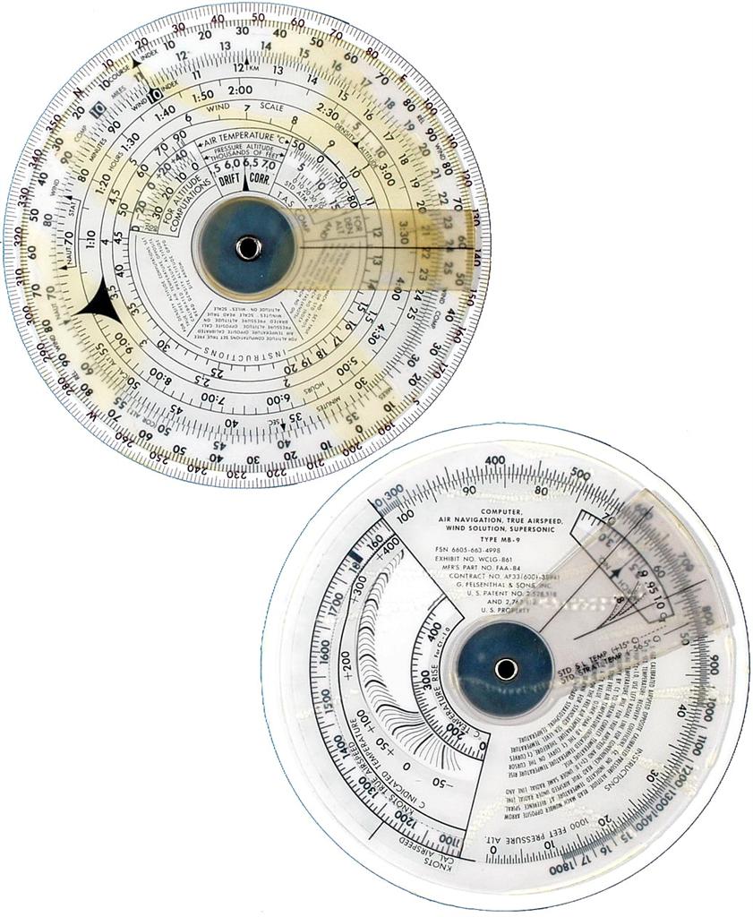
The MB-2A is very similar to the MB-9 pictured here:
http://www.rekeninstrumenten.nl/pages%20and%20pictures/12071.jpg
except the true airspeed goes up to 1800 knots on the MB-9 while it only goes up to 1000 knots on the MB-2A. Since I don't fly planes that can exceed 1000 knots I prefer the MB-2A since its more limited speed range allows an expanded scale for the range it covers.
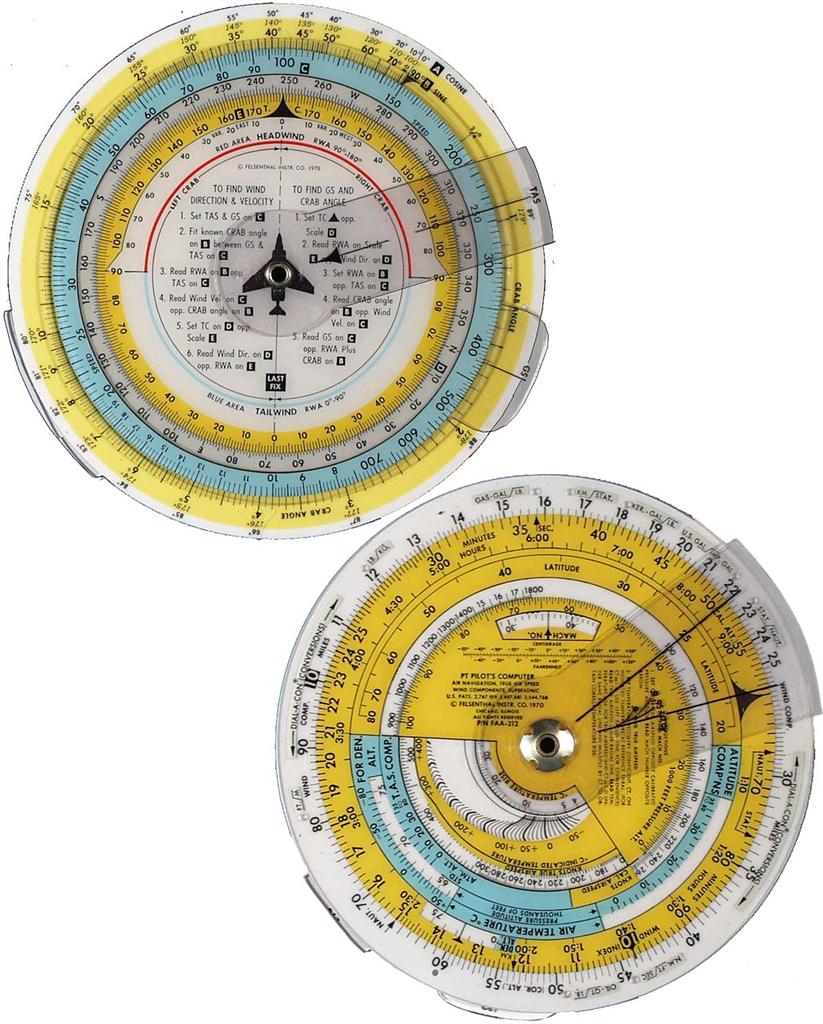
It is very similar to the Felesenthal PT computer pictured here:
http://www.rekeninstrumenten.nl/pages%20and%20pictures/12141.jpg
in that each of these computers solve the wind triangle with trig, no vector diagram is drawn.
The Jeppesen CR-3 pictured here:
http://sliderule.mraiow.com/wiki/Jeppesen_CR-3
uses a diagram on the back to determine wind factors so its method is completely different than the previous computers. All of these are similar in that they have the standard time-speed-distance scales and they allow for compressibility in computing true airspeed.
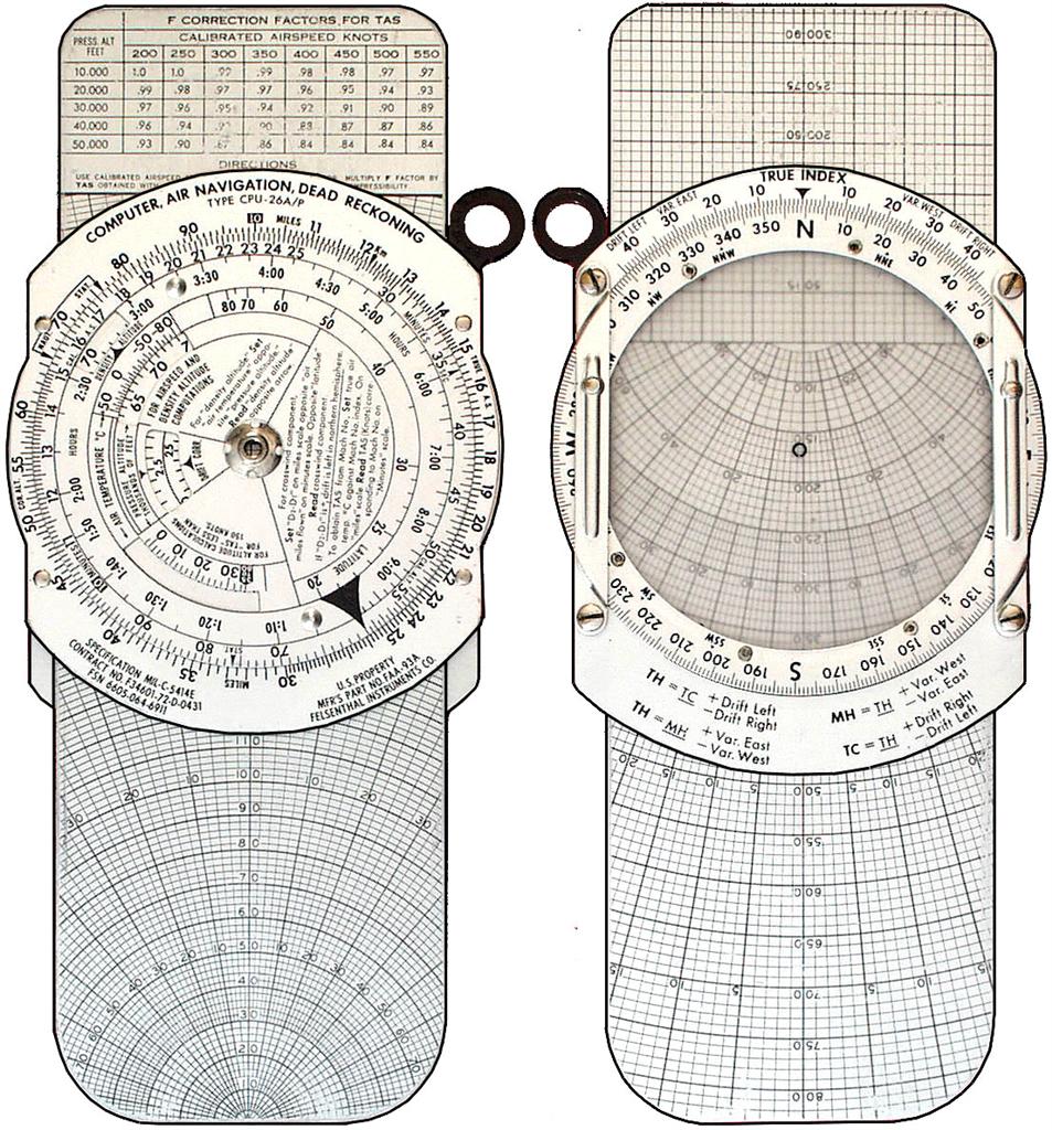
The original E-6B pictured here:
http://www.rekeninstrumenten.nl/pages%20and%20pictures/12081.jpg
uses a wind vector diagram on the back and does not allow for compressibility in TAS computations.
gl
Greg R. wrote:
--~--~---------~--~----~------------~-------~--~----~
Navigation List archive: www.fer3.com/arc
To post, email NavList@fer3.com
To , email NavList-@fer3.com
-~----------~----~----~----~------~----~------~--~---
With the exception of the red numbers on the outside rings, your MB-2A
computer looks remarkably similar to the Jeppesen CR series (CR-3,
CR-6, etc.) - is it maybe a military version (or an earlier version)of
the Jepp one?
Gary LaPook responds:
The MB-2A is very similar to the MB-9 pictured here:
http://www.rekeninstrumenten.nl/pages%20and%20pictures/12071.jpg
except the true airspeed goes up to 1800 knots on the MB-9 while it only goes up to 1000 knots on the MB-2A. Since I don't fly planes that can exceed 1000 knots I prefer the MB-2A since its more limited speed range allows an expanded scale for the range it covers.
It is very similar to the Felesenthal PT computer pictured here:
http://www.rekeninstrumenten.nl/pages%20and%20pictures/12141.jpg
in that each of these computers solve the wind triangle with trig, no vector diagram is drawn.
The Jeppesen CR-3 pictured here:
http://sliderule.mraiow.com/wiki/Jeppesen_CR-3
uses a diagram on the back to determine wind factors so its method is completely different than the previous computers. All of these are similar in that they have the standard time-speed-distance scales and they allow for compressibility in computing true airspeed.
The original E-6B pictured here:
http://www.rekeninstrumenten.nl/pages%20and%20pictures/12081.jpg
uses a wind vector diagram on the back and does not allow for compressibility in TAS computations.
gl
Greg R. wrote:
With the exception of the red numbers on the outside rings, your MB-2A
computer looks remarkably similar to the Jeppesen CR series (CR-3,
CR-6, etc.) - is it maybe a military version (or an earlier version)of
the Jepp one?

And I assume this isn't the other calculator that you alluded to
earlier (Barger, or something similar?) - it's late and I can't find
that particular post right now.

--
GregR


--- "Gary J. LaPook" <glapook@pacbell.net> wrote:
Gary J. LaPook wrote:Being the conscientious navigator that I am, I followed my usual practice of memorizing some data from the 2008 Nautical Almanac so that I would have it available for emergency use. The first thing I memorized was the GHA of Aires at 0000 Z January1,2008 which is 100º 01.9' and also remembering that Aires advances 59.139' each day. With this information you can calculate GHA Airesfor 0000 Z on June 9, 2008 which is the 161st day of the year butisonly 160 days from January 1st. So multiplying 59.139' times 160daysgives 157º 42.2' to which you add the starting value of 100º01.9'to come up with the GHA Aires on June 9th at 0000 Z of 257º 44.1'.Tothis you add the change of GHA for the time since 0000 Z (3 hours42minutes 10 seconds for the Vega shot) by multiplying the timeintervalby the rate of change of 15.041º per hour making 55º 41.6' makingtheGHA Aires at the time of the Vega shot of 313 º 25.7'. I also memorized the SHAs and the Declinations of ten of the navigation stars ( nobody could memorize all 57) which should be enough for emergency use as tabulated for July 1st so that thevalueswill be reasonable for the whole year. Fortunately this includedthethree stars used in this exercise. So now adding the SHA of Vega,80º41' we end up with the GHA of Vega of 34º 06.7' and using the D.R.asthe A.P. we get an LHA of 274º 48' and the declination of 38º 47'N.(rounded to the whole minute) Using these values on my Bygrave slide rule (see attached worksheet)since I have no tables with me, I computed Hc of 23º 59'. The Hs given was 24º 05.5' Computing the dip correction in my headof4.5' (the square root of 20 must be between 4 and 5 ) and applyingtherefraction correction of minus 2 gives an Ho of 23º 59' giving and intercept of zero and an azimuth of 58.1 º. I long ago memorizedtherefraction table for altitudes above 10º in The Air Almanac and inH.O249, the cutoff values are 63-33-21-16-12-10º , zero above 63, 1above33, 2 above 21, 3 above 16, 4 above 12 and 5 above 10. I used the same procedure for Spica and Pollux getting another zerointercept for Pollux, Zn of 290.2º and a 4 NM away for Spica withaZn of 171.7º. Since I am on the road I do not have any of my plotting tools withmeso I had to make do with what I found in my briefcase. I used myMB-2Aflight computer since it had an azimuth scale and I used a pad of paper with a right angle at the corner as my straight edge for plotting the LOPs. I used a tape measure from IKEA to measure the length of the intercept (see photo.) I plotted the LOPs and foundthefix by bisecting the three angles giving a fix .4 NM west of theA.P.(D.R.) and 2.8 NM north of it. (Plotting a fix as a distance fromtheA.P. like this is common in aerial practice and it is often done onanE-6B.) Adding the 2.8 NM north to the D.R. latitude gives a fix latitude of 34º 16' North. To convert the .4 NM west to alongitudeyou divide the .4 NM by the cosine of the latitude, .82, to findthedifference in longitude of .5' so the fix longitude is 119º 19.5' West (rounded to either 119º 19' or 20'.) ( I got the cosine of34ºby finding the sine of 56º on the MB-2A sine scale, used for wind correction calculations.) My fix might not be in agreement with others but I used arefractiontable tabulated in whole minutes, I only memorized the stars' positions to the nearest minute and I did not have any plottingtoolsto use but my position is certainly good enough for emergency navigation and done without an almanac, tables or electrons. gl 1 m_burkes@msn.com wrote:Captain Lecky would be proud of those dividers ha! Speaking of interpolation I have found a neat way to get around that pesky DSDandinterpolation tables by using the aviation E6B computer or the equivalent nautical slide rule. Essentially the setup:d-value/60=d-correction/declination minutes. Yes the calculator offers theproof.Mike Burkes On Jun 12, 11:44 pm, Anabasi...@aol.com wrote:Thanks for the nice exercise Greg. I literally had to dust offthe ship'sVol III of HO 229 and deflower a Plotting sheet 925 to work thisone out.Since I was bereft of electronic gadgets, I did this with aplotting sheet,2 triangles, a pair of dividers, 2 books, a pencil, and smallpiece of scratchpaper (wouldn't have reams of paper in the Lifeboat). I haveattached apicture in to this message with the plot and the tools. My Lat is a bit lower (plotting or math error?). I used anassumed positionmethod and HO 229. I had to assume we were drifting and nocurrent (didn'tadvance or retard the lines). I had not done a full HO 229 paperreductionof a star in many years, and I had to think a second to rememberhow to usethe interpolation pages on the inside covers for the declinationinterpolation.I usually whip those off with the calculator. Still, I gotpretty close tothe computer solutions with Lat 34deg 11.9' N and Longitude119deg 16.0'W.As to how you would get an Eastern sight on the west coast, youwould have 2options in general. The first would be a back sight. This wouldbeparticularly difficult with a regular sextant at such a lowaltitude. The otheroption would be to use a bubble sight tube or other artificialhorizon. If youwere across a bay, you could also use a dip short of the horizontable.That's all I can think of at the moment. Jeremy **************Vote for your city's best dining and nightlife.City's Best2008. (http://citysbest.aol.com?ncid=aolacg00050000000102) gregExerPlot.jpg.JPG 182KViewDownload GregExerTools.jpg.JPG 129KViewDownload
--~--~---------~--~----~------------~-------~--~----~
Navigation List archive: www.fer3.com/arc
To post, email NavList@fer3.com
To , email NavList-@fer3.com
-~----------~----~----~----~------~----~------~--~---


