NavList:
A Community Devoted to the Preservation and Practice of Celestial Navigation and Other Methods of Traditional Wayfinding
From: Andrés Ruiz
Date: 2008 Jun 11, 08:36 +0200
Greg, GPS?, Navigator?, with all lost at sea, :-)
I use the Sight Reduction with calculator, Form & Plotting sheet for celestial LoPs at http://www.geocities.com/andresruizgonzalez/marinenavigation.html for manually SR, but this takes a lot of time, and is prone to errors, and I prefer to use the programs written by me aboard an 8 m sailboat. I am an engineer and for me the time of table and abacus has gone, yes astronavigation but with 21st century tools, why not?.
In Spain, in order to obtain the captain license for a private yacht, you have to pass an exam that includes Celestial navigation, naval kinematics, rhumb line and GC sailings,… and of course you can use tables, but the people usually prefers a non programmed calculator.
I have found people that uses the almanac and the tables as a cook recipe, yes they reach a fix, but really they don’t know what are they doing.
Well ---
For time for Pollux UT1: 21:00:50
The solution is:
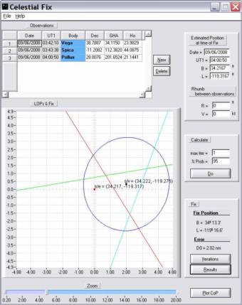
34º 13.3' N 119º 16.6' W, both, solving for 3 LoP, (DeWit , LopLSSR), and solving for 3 CoP, (Circles of Position or Circles of Equal Altitude, Kaplan)
Navigator: I think the method it uses is not the best, is a manually approximation.
For anyone who wants to do manual calculations, the LoP of Pollux is:
Fecha y hora UT1
09/06/2008
04:00:50
SITUACION ESTIMADA
Latitud: Be = 34.216667 º = 34º 13.0'
Longitud: Le = -119.316667 º = -119º 19.0'
ALMANAQUE NAUTICO
Cuerpo celeste: Estrella Pollux
Polo de iluminacion del astro: Coordenadas Ecuatoriales
GHA = 201.652447 º = 201º 39.1'
Dec = 28.007559 º = 28º 0.5'
Correcciones altura:
SD = 0.000000 '
HP = 0.000000 '
CORRECION DE LA ALTURA
altura sextante [º]: Hs = 21.2583 = 21º 15.5'
correcion de indice [']: ie = 0.0000
altura del ojo sobre el nivel del mar [m]: heas = 6.0960
temperatura ambiente [ºC]: T = 10.0000
presion atmosferica [mb]: P = 1010.0000
en [º]:
altura observada por el sextante: Hos = 21.2583
depresion del horizonte: dip = 0.0724
altura aparente: Ha = 21.1859
correcion por refraccion: R = 0.0418
correcion por achatamiento: OB = 0.0000
Paralaje horizontal: HP = 0.0000
correcion por paralaje: PA = 0.0000
semidiametro: SD = 0.0000
Augmentation of SD = 0.0000
altura observada corregida: Ho = 21.1441 = 21º 8.6'
DETERMINANTE DE LA RECTA DE ALTURA
Angulo Horario Local: LHA = 82.335781 º = 82º 20.1'
Coordenadas Horizontales: Hc, Z
Altura Calculada: Hc = 21.1880 º = 21º 11.3'
Azimut: Z = 290.2 º
p = Ho-Hc = -0.043838 º = -2.630267 '
(Here s/e is the DR position, and s/v is the true one). I have attached the input file for this program.
Greg, the Celestial Fix program is developer by me, and is gratis at my website.
The Plot CoP pushbutton call a program that plot on a shoreline Mercator chart the Circles of Position. The interface is from the NavList member Michael Dorl, and the algorithms is by me using vectors instead of spherical trigonometry.
Andrés
-----Mensaje original-----
De: NavList@fer3.com [mailto:NavList@fer3.com] En nombre de Greg
R.
Enviado el: martes, 10 de junio de 2008 21:58
Para: NavList@fer3.com
Asunto: [NavList 5392] [SOLUTION] Re: [NavList 5391] RE: 3-Star Fix -
"Canned Survival Problem"
--- Andres Ruiz <aruiz@orona.es> wrote:
> 34º 11.0' -119º 9.9'
Hi Andres:
Your solution is accurate to within a few miles (actual GPS position is
34°14.4’N / 119°15.9’W), and the intrepid navigator thanks you for the
timely rescue. :-)
But I think you missed this part of the problem: "the navigation
computer and calculators were all lost at sea" (unless you really want
us to believe that you can do the spherical trigonometry calculations
to 15-16 decimal point accuracy manually...). ;-)
That being said, I do like the look of the user interface that you
attached (especially the fact that it shows the circles of position on
a small scale map) - what program is that?
Interestingly enough, Navigator gives a position of 34° 12.6'N / 119°
16.5'W, so I guess the programs all use slightly different computation
methods to arrive at a solution.
--
GregR
--~--~---------~--~----~------------~-------~--~----~
Navigation List archive: www.fer3.com/arc
To post, email NavList@fer3.com
To , email NavList-@fer3.com
-~----------~----~----~----~------~----~------~--~---


