38Talk:
A Forum for Discussions among Voyagers and Others related to the 38th Voyage of the Charles W. Morgan


From: UNK
Date: 2014 Aug 21, 12:02 +0000
Hello Frank,
I have now posted the final entry of my whale ship blog. Please feel free to distribute it among the listserve if you wish. I never am sure whether I am writing
to the list serve or just to you, so I hope you will get this and sort things ont. I have tried to proofread this, but it was all written pretty much on the fly, so if anyone has corrections, I would greatly appreciate receiving them. Thanks so much for
creating the listserve. It has been a great gift to us all.
Bob Wallace (Martha’s Vineyard to New Bedford)
From: 38Talk@fer3.com [mailto:38Talk@fer3.com]
On Behalf Of Frank Reed
Sent: Thursday, August 14, 2014 6:31 PM
To: Robert Wallace
Subject: [38Talk] A map of the last day, and a sticky spot
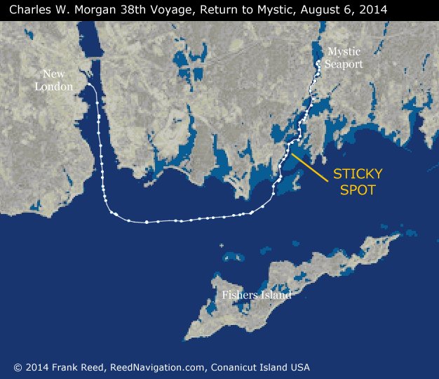
One of the challenges for future voyages of the Charles W. Morgan is the restricted navigability of the Mystic River estuary. A narrow channel runs from Mystic Seaport, through the US-1 highway drawbridge and the northeast
corridor rail bridge, and then snakes past Mason's Island and the peninsula of Noank before passing between tricky shoals and rocks leading out into Fishers Island Sound. The Morgan has to be rigged down and de-ballasted somewhat in order to make it through
this obstacle course. And even so, she got stuck. I didn't see the delay on the outbound leg, which locals tell me lasted a little longer. Coming back upriver last week, the Morgan got stuck for about a minute at the "sticky spot" (see the attached map). That's
not long, but this is a serious issue. In order to sail again, the Morgan will have to repeat the ballasting/de-ballasting process in New London before heading out on any sailing treks, and it needs a tow through all of this. Those who are interested in seeing
the Morgan sail again may want to investigate the process of convincing the Corps of Engineers (or whoever is responsible --I don't know) to dredge the Mystic River channel deeper and wider. That would certainly simplify the process. Of course there are environmental
concerns with any dredging. Is sailing the Morgan worth that cost? And if it means losing a few mooring sites in the anchorages along the channel, would local enthusiasm wane?
The attached map is a continuation of the voyage mapping that I described earlier. I collected the AIS data (GPS positiions broadcast by vessels and recorded by shore receivers) for the Morgan, the tug Sirius, and Roann. I
combined these points for this very last leg of the voyage. You can see the tight squeeze up the channel to return the Morgan to Mystic Seaport.
Frank Reed
ReedNavigation.com
Conanicut Island USA
Attached File:
(CWM-sticky-spot.jpg: Open and save)